🏔 【Beacon Hill】 (457m, locally known as Pat Ka Shan or Bik Ka Shan) is a prominent peak in central Kowloon and forms part of Lion Rock Country Park. The mountain earned its traditional Chinese name “Pat Ka Shan” from its unique shape, which closely resembles a traditional Chinese calligraphy brush rest (“Pat Ka”). Its historical Chinese name “Yim Dun Shan” (Smoke Mound Hill) and its English name, Beacon Hill, both hint at its past coastal defense role as a site for smoke signal stations or beacons. Deep inside, the Beacon Hill Tunnel cuts through the mountain to connect Kowloon Tong with Sha Tin, while its summit houses a Civil Aviation Department radar station—a critical piece of Hong Kong’s air traffic control network that keeps the skies and airport running smoothly. —
📌 Fast Facts
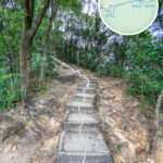
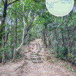
Category Details 🏞 Chinese Name 筆架山 (Beacon Hill, also commonly written as 畢架山, historically known as 煙墩山) ✒️ Name Origin Chinese name comes from its brush-rest silhouette; English name means “Smoke Beacon Station,” translating its historical defense role. 📏 Elevation Approx. 457–458 meters (1,499 feet) 🗺 Location Sits right on the border between Western Kowloon and Eastern New Territories, flanking Kowloon Tong, Shek Kip Mei, and Tai Wo Ping. 🧭 Mountain Range Kowloon Hills; bordered by Lion Rock to the east, Sharp Hill to the northwest, and Crow’s Nest to the west. 🌳 Country Park Nestled within Lion Rock Country Park. 📍 Coordinates 22°20′59.19″N, 114°10′12.51″E 🏘 Foothill Developments An upscale residential pocket featuring Beacon Heights, Dynasty Heights, Beacon Hill Villa, and One Beacon Hill. 🛰 Summit Facilities Civil Aviation Department (CAD) Radar Station, used for tracking flight paths and managing local airspace. 🚇 Tunnel Infrastructure Beacon Hill Tunnel (originally the Old Beacon Hill Tunnel), linking Kowloon Tong to the Eastern New Territories, now operated by the MTR. 🚶♂️ Hiking Routes Lung Yan Road, MacLehose Trail Section 5, Sam Yee Path, Kwai Fei Path, and the War Relics Trail. 🏰 Historical Context Home to a Qing Dynasty smoke beacon station; later served as the central sector of the Gin Drinkers Line during WWII, leaving behind military relics like pillboxes and coordinate stones. — Beacon Hill is far more than just a vital infrastructure and transport corridor; it is also a treasure trove of biodiversity and historical wartime memories. The surrounding slopes are designated as a Site of Special Scientific Interest (SSSI) due to the discovery of rare wild orchid species. Hiking along MacLehose Trail Section 5, which winds across the foothills, outdoor lovers can explore concrete trenches, military pillboxes, and artillery coordinate stones left behind from the WWII Gin Drinkers Line. Popular routes include trekking up from Lung Cheung Road via Lung Yan Road to the peak, or starting out from Beacon House—mostly paved with concrete, making it an easy, beginner-friendly hike. The iconic “white golf ball” radar dome at the summit is a famous landmark, serving up incredible vistas over the Kowloon Peninsula and Victoria Harbour. —
🗺️ Geography & Landscape Overview
- Location: Situated in Western Kowloon, Beacon Hill is nestled squarely between Kowloon Tong, Shek Kip Mei, and Tai Wo Ping, standing proud as part of the Kowloon Hills.
- Elevation: At roughly 457 meters (1,499 feet), it stands as one of the loftier peaks overlooking the Kowloon basin.
- Neighboring Peaks:
- East: Lion Rock
- Northwest: Sharp Hill (Tsim Shan)
- West: Crow’s Nest (Nga Yau Shan)
- Conservation: Fully protected under the green canopy of Lion Rock Country Park.
— The area around Beacon Hill offers an interesting mix of vibes. Its southwestern foothills have evolved into a highly sought-after luxury residential neighborhood, while major institutions like the Hong Kong Baptist Hospital flank Waterloo Road below. On the transit side, residents enjoy easy bus access straight into the New Territories, alongside green minibus links directly to Kowloon Tong MTR Station. Perfectly marrying natural greenery, wartime history, and urban energy, Beacon Hill stands out as a fascinating and multi-layered Hong Kong landmark. —
🏰 History & Name Origins
- Historical Name “Yim Dun Shan”: During the Qing Dynasty, a coastal defense beacon station (“煙墩”) was built here to burn grass and release smoke signals during emergencies.
- English Name “Beacon Hill”: A literal translation of its historical role, referring directly to the military signal beacons.
- Chinese Name “Pat Ka Shan”: Named because the rolling peaks closely resemble the profile of an old-school Chinese calligraphy brush rest; it has no direct phonetic connection to the English name.
- The “Bik Ka Shan” Typo: While often written colloquially using alternative characters (“畢架山”), the traditional, original name is firmly rooted in the writing brush rest (“筆架山”).
—
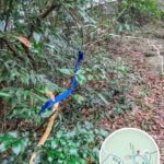
🛡️ Military Relics & Wartime History
As a core stronghold along the legendary Gin Drinkers Line, Beacon Hill still retains an impressive array of WWII military artifacts:
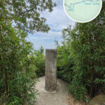
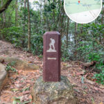
Relic Type Key Features Pillboxes / Bunkers Multiple concrete machine-gun positions scattered along the strategic ridge lines. Underground Tunnels Subterranean dugouts used for air raids, shelter, and frontline communications. Artillery Coordinate Stones Features the largest military positioning stone in Hong Kong, used by British artillery to calibrate firing ranges. War Relics Trail A heritage hiking trail lined with informational boards that unpack the local wartime history. 📍 History buffs can easily check out these relic zones by branching off from MacLehose Trail Section 5 or Sam Yee Path. —
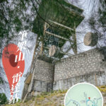
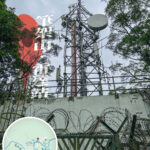
🛰️ Beacon Hill Radar Station
- Operator: Managed and maintained by the Hong Kong Civil Aviation Department (CAD).
- Role: Acts as a crucial eye in the sky for air traffic control, backing flight scheduling and safety at Hong Kong International Airport.
- Facilities: Features the signature massive radar dome at the summit, with Lung Yan Road serving as the restricted access route for maintenance crews.
—
🏡 Upscale Residential Development
Boasting commanding views of the city below, the foothills of Beacon Hill have long been a premier luxury residential hot spot in Kowloon:
Sham Shui Po District (Tai Wo Ping Area)
- Beacon Heights
- Dynasty Heights
Kowloon City District (Broadcast Drive Area)
- Beacon Hill Villa
- Beacon Hill No.1
- Broadcast Drive – Famously nicknamed “Five Television Hills” in Cantonese back in the day, as it once housed the headquarters of five major TV and radio stations.
📌 The area was originally home to “Kai Liu Village” (a settlement of flower farmers dating back over 80 years), which was cleared in 1959 to make way for the major intersection of Lung Cheung Road and Waterloo Road. —
🏫 Education & Medical Institutions
- Beacon Hill School: A premier international primary school run by the English Schools Foundation (ESF), located at the corner of Ede Road and Hornton Road.
- Hong Kong Baptist Hospital:
- Established back in 1963.
- Located at 222 Waterloo Road.
- A well-known, private faith-based general hospital offering a full suite of medical services.
—
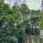
🚶 Hiking Routes & Vantage Points
Beacon Hill is a major hit with the local hiking community, offering steady, straightforward trails that are perfect for beginners:
Starting Point Route Beacon House (Wong Tai Sin) Lung Yan Road → Beacon Hill Viewing Point → Kowloon Pass → Lion Rock Park → Chuk Yuen Road
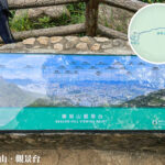
- The trail serves up breathtaking, bird’s-eye views over urban Kowloon, Hong Kong Island, Lei Yue Mun, and the wider Victoria Harbour.
- The Beacon Hill Viewing Point is a legendary spot for night photography and snapping that perfect shot with Lion Rock in the frame.
⚠️ Safety Tip: The trail has seen isolated incidents of trail robberies in the past, so hiking solo isn’t recommended. Pavilions and trash bins are scattered along the way, but remember to bring plenty of water and stay aware of your surroundings. —
🚍 Getting There & Around
Destination Transit Options Hong Kong Island Bound Hop on a free shuttle bus down to Lok Fu Station, or take green minibus 29B straight to Kowloon Tong Station. New Territories Bound The nearby Ying Yuet Tong bus stop features an array of routes heading out to Sheung Shui, Fanling, Tai Po, Ma On Shan, and Sha Tin. Hiking Trailheads Simply catch KMB route 42C, or any bus/minibus passing by Beacon House on Lung Cheung Road in Wong Tai Sin, and hop off. —