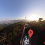
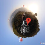
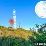
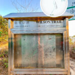
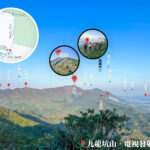
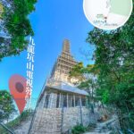
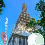
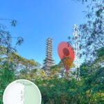
🏔️ 【Cloudy Hill / Kowloon Hang Shan (九龍坑山)】 is a prominent peak in the northeastern New Territories of Hong Kong, standing at an altitude of 440 metres. Situated on the border between Tai Po District and North District, it lies within the boundaries of Pat Sin Leng Country Park. The mountain marks the end of Wilson Trail • Section 8 and the start of Section 9. The summit features a triangulation station and a television transmission tower, offering an expansive 360-degree panoramic view over Lam Tsuen Valley, Tai Po Town, Tolo Harbour, and the Shenzhen border. The open vistas are exceptionally spectacular at sunset when the city lights begin to blend with the seascape. Originally named “Hop Wan Shan” (Cloud-Gathering Mountain), it was later named after the village of Kowloon Hang at its western base, where multiple mountain streams once converged. While the overall ridgeline is relatively gentle, the trails are strewn with loose rocks and require about 2 hours to ascend, making it a classic warm-up route before tackling the more demanding peaks of Pat Sin Leng or Wong Leng. —
📌 Key Information
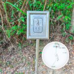
Category Details 🗻 Name Cloudy Hill (Kowloon Hang Shan), also historically known as Hop Wan Shan or Wan Shan 📍 Location Northern New Territories, Hong Kong; north of Tai Po and southeast of Fanling, within Pat Sin Leng Country Park 📏 Elevation Main Peak: 440 metres; Secondary Peak (Tai Shan Mei): 419 metres 🧭 Coordinates 22°28′33.21″N, 114°10′13.87″E 🏞 Geographical Features Comprises twin peaks flanked by Kowloon Hang Village to the west, Sha Lo Tung to the east, and connecting to the main Pat Sin Leng range to the north 📡 Facilities Features a digital terrestrial television transmission station on the summit, serving Tai Po, Ma On Shan, Fanling, and Sheung Shui districts 🧭 Hiking Routes Serves as the junction of Wilson Trail Sections 8 and 9; the classic “Sky Ladder” route spans about 7.5 km, taking roughly 3.5 hours with a moderate-to-high difficulty rating 🪜 Sky Ladder Features Features approximately 3,000 steps interspersed with pavilions and rest areas, offering sweeping views of Hong Lok Yuen, Tolo Harbour, and Ma On Shan along the climb 🦋 Ecological Value Bordered by Sha Lo Tung, a designated Site of Special Scientific Interest (SSSI) providing crucial habitat for rare species like Romer’s Tree Frog and 43 distinct butterfly species including the Painted Lady and Common Bluebottle 🐸 Rare Species Includes Romer’s Tree Frog, rare dragonflies, and a diverse array of butterfly populations 🏛 Culture & History Kowloon Hang Village preserves Hakka heritage, while the Tang Chung Ling Ancestral Hall stands as a monument to Hakka migration; the old village dwellings of Sha Lo Tung are listed as Grade 2 Historic Buildings 🌾 Seasonal Scenery Silvergrass blooms abundantly in autumn and winter, and the mist-shrouded summit offers an ethereal, dreamlike landscape; spring and summer bring vibrant butterfly activity ideal for eco-watching — Cloudy Hill boasts a rich tapestry of natural ecology and historical footprints. The mountain structure is primarily composed of volcanic rock, covered with a mix of secondary forests and shrubland that shelter local wildlife such as barking deer and East Asian porcupines. To the northeast, the Sha Lo Tung valley forms the largest freshwater wetland in Hong Kong, recording over 80 species of dragonflies and rare amphibians. Meanwhile, Fung Yuen Valley at the southern foot functions as a renowned butterfly conservation area. In terms of historical heritage, the ridge retains remnants of military trenches and pillboxes constructed by British forces as defensive lines during World War II. At the base of the hill, Kowloon Hang Village preserves traditional Hakka houses and ancestral halls, standing as a testament to the evolution of New Territories rural life. Furthermore, the transmission tower erected at the summit has been a cornerstone of Hong Kong’s broadcasting infrastructure since the 1960s. —
📍 Geographical Context & Origin of Name
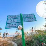
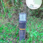
Located north of Tai Po and southeast of Fanling, Cloudy Hill forms an integral part of the northeastern New Territories mountain system. The Chinese name is derived from Kowloon Hang Village at its southwestern foot, while its English name, “Cloudy Hill,” vividly describes how the peak is frequently enveloped in low-hanging clouds and mist. — The ascent typically begins from Tai Po Tau Drive or Tai Hang Village, climbing along the trail near Wilson Trail marker W100. This direct approach spans roughly 3 km and takes 2 to 3 hours, featuring moderate gradients with a few steep pitches. For transportation, hikers can take KMB bus route 64K from Tai Po Market Station to the Kowloon Hang stop, or walk to Tai Hang Village from Fanling Station. A complete traverse descending via Hok Tau Reservoir or Sha Lo Tung towards Fanling takes about 4 to 5 hours. While less crowded than other famous peaks, its exceptional blend of geology, wartime history, and expansive views makes it a rewarding hidden gem. Notably, Kowloon Hang Lo Wai (Walled Village) halfway up the slope showcases authentic Hakka architecture, and Kwong Fuk Bridge at the base serves as a historical 1920s link between Tai Po and Fanling. —
🥾 Hiking Routes
🔹 Tai Wo Station to Summit
Classic Route: Tai Wo Station ➝ Cloudy Hill ➝ Lau Shui Heung Reservoir
- Total Distance: Approx. 10.8 km
- Highlight: Features a challenging climb up over 3,000 stone steps, widely celebrated as “Hong Kong’s Sky Ladder.”
- Offers unobstructed vantage points overlooking Hong Lok Yuen and Tolo Harbour.
- Total Ascent: Approx. 699 metres
- Time Required: Approx. 4.5 hours (Intermediate difficulty)
- Starting Point: Tai Wo MTR Station, Exit A
- Ending Point: Lau Shui Heung Reservoir or Sha Lo Tung
🔹 Wilson Trail Connection
- Jumps directly from the end of Section 8 straight into Section 9.
- Recognized as one of the most physically demanding long-distance trail segments in Hong Kong.
⚠️ Hiking Safety & Gear Tips
- Wear sturdy hiking shoes with excellent grip to tackle the loose gravel sections.
- Carry adequate drinking water (at least 2 litres is highly recommended).
- Equip proper sun protection, including hats, sunglasses, and sunscreen.
- Utilizing trekking poles is highly beneficial for managing the steep step count of the Sky Ladder.
- There are no trailside shops on the mountain; ensure all supplies are purchased beforehand at Tai Wo Station or Tai Po Tau Village.
—
⛰️ Trail Features & Landscapes
- Cloudy Hill Sky Ladder: Over 2,000 continuous stone steps that serve as an excellent test of stamina and leg endurance.
- Silvergrass Fields: Turning the hillsides into a shimmering sea of gold during the late autumn and winter seasons.
- Tolo Harbour Vistas: Reaching the summit rewards hikers with panoramic views stretching across Tolo Harbour, Ma On Shan, and the Pat Sin Leng range.
—
🦋 Conservation Hotspots
Site Details Fung Yuen Butterfly Reserve Located at the southeastern foot of Cloudy Hill, recording a vast population of over 150 butterfly species. Sha Lo Tung Wetland A designated Site of Special Scientific Interest (SSSI), providing pristine habitats for unique frogs, dragonflies, and rare flora. —
🌿 Ecology & Natural Sights
🦋 Butterfly Watching
- Positioned right within the ecological corridor of the Fung Yuen Butterfly Reserve.
- Frequently spotted species include the Common Bluebottle, Great Mormon, and Cruiser butterfly.
- Peak viewing hours generally fall between 9:30 AM and 4:30 PM on sunny days.
🌾 Autumn Silvergrass
- The upper slopes come alive with silvergrass during cooler months, creating picturesque golden meadows.
- Sunset provides the most dramatic lighting, making it a prime window for landscape photography.
—
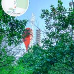
📡 Summit Infrastructure
- Houses the key digital terrestrial television transmitter covering the wider Tai Po, Ma On Shan, Fanling, and Sheung Shui residential zones.
- The summit features standard survey markers and paved maintenance access roads, though parts are gated against public vehicular access.
—
🛕 Cultural Heritage
Historical Site Details Queen’s Hill Hindu Temple Built in the 1960s to serve the spiritual needs of the Gurkha soldiers stationed nearby; currently classified as a Grade 3 Historic Building. —