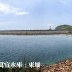
🛣️【Sai Kung • Man Yee Road (西貢 • 萬宜路)】 is a critical infrastructural corridor nestled within the eastern reaches of the Sai Kung District, New Territories, Hong Kong. Stretching approximately 9.65 kilometers, it tracks along the scenic southwestern shoreline of the High Island Reservoir, holding the unique distinction of being the easternmost drivable roadway in Hong Kong. The road originates at Pak Tam Chung—where it junctions with Tai Mong Tsai Road and Sai Kung Sai Wan Road—and wends its way to the spectacular terminal at the High Island Reservoir • East Dam. Along the alignment, it passes the High Island Reservoir • West Dam, the Chong Hing Water Sports Centre, and provides access points to several traditional coastal villages on High Island (Leung Shuen Wan), including Pak A, Tung A, and Pak Lap. It also serves as the structural backbone for Section 1 of the MacLehose Trail, making it a highly popular destination for holiday trekkers and nature enthusiasts. —
📌 Key Road Profile
Item Details 🏞️ English Name Sai Kung Man Yee Road (西貢 • 萬宜路) 📍 Geographic Location Sai Kung District, Eastern New Territories; entirely enclosed within Sai Kung East Country Park 📏 Total Length Approx. 9.65 km (6 miles) 🧭 Starting Point Pak Tam Chung (junctions with Tai Mong Tsai Road and Sai Kung Sai Wan Road) 🧭 Ending Point High Island Reservoir • East Dam 🚗 Traffic Alignment Single-lane single carriageway with passing bays; handles two-way traffic 🚌 Public Transit New Territories Green Minibus Route 9A (operational on Sundays and Public Holidays only) 🚧 Management Authority Water Supplies Department (WSD) 🚫 Access Restrictions Strictly restricted. Closed to general private vehicles and bicycles; access is permitted only to permit holders, urban/New Territories taxis, and authorized public transit 🏗️ Historical Context Constructed in the 1970s to facilitate the building and maintenance of the High Island Reservoir scheme — Sai Kung Mand Yee Road was originally carved out as a dedicated heavy-vehicle construction and maintenance route for the High Island Reservoir water scheme. Officially opened to service in the 1970s, it was later integrated into the country park network for public pedestrian enjoyment, though its core maintenance and infrastructure operations remain under the strict jurisdiction of the Water Supplies Department. Because it operates as an active waterworks catchment track inside the boundary of Sai Kung East Country Park, any motor vehicle entering the road must secure official entry permits from both the Agriculture, Fisheries and Conservation Department (AFCD) and the WSD. General private cars, delivery fleets, and standard bicycles are strictly prohibited from entry. The only vehicles permitted on the road are official permit holders, commercial taxis, government service vehicles, and the New Territories Green Minibus Route 9A, which operates scheduled services during holidays. —
🗺️ Geographic Route Layout
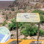
The road originates at Pak Tam Chung and snakes eastward to terminate at the High Island Reservoir • East Dam. Key landmarks and trail waypoints encountered along this route include:
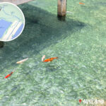
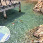
- 🏕️ Chong Hing Water Sports Centre: A specialized outdoor recreational facility fronting the inner lagoon.
- 🏞️ High Island Reservoir • West Dam: The expansive western retaining barrier offering wide reservoir vistas.
- 🏡 Traditional Hakka Villages: Overland link points to the indigenous coastal settlements of Pak A, Tung A, and Pak Lap.
- 🥾 MacLehose Trail Section 1: A smooth, paved trail segment tracking alongside the reservoir basin.
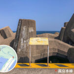
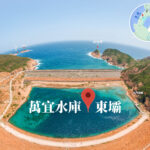
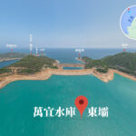
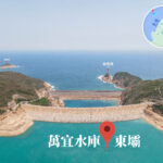
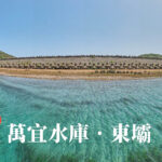
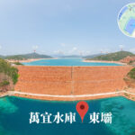
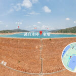
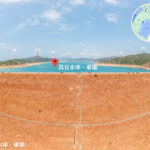
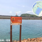
— This thoroughfare serves as the singular overland gateway to both the East and West Dams of the High Island Reservoir. The East Dam area forms a core geo-area of the Hong Kong UNESCO Global Geopark, showcasing world-renowned geological marvels, structural breakwaters, and the wave-cut sea stack of Po Pin Chau. To accommodate the massive influx of eco-tourists, the New Territories Green Minibus Route 9A provides full-day holiday transit services (running from 9:30 AM to 7:00 PM) on Sundays and Public Holidays. Sai Kung Man Yee Road stands out not just as a vital piece of water resource infrastructure, but as a unique scenic route that links epic civil engineering feats with striking volcanic rock formations and world-class wilderness hiking. —
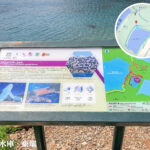
🌋 Geological & Natural Wonders
The landscapes surrounding the East Dam terminal belong to the Hong Kong UNESCO Global Geopark and feature several world-class geographical formations:
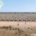
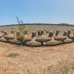
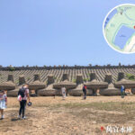
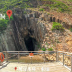
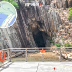
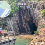
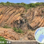
- 🪨 Hexagonal Volcanic Columns: Spectacular rock faces formed during prehistoric volcanic eruptions, cooling into uniform, honeycomb-like columns.
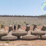
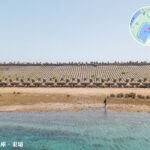
- 🌊 Dolosse Breakwater: A massive engineering seawall comprised of interlocking, anchor-shaped concrete blocks designed to dissipate ocean swell energy.
- 🌄 Po Pin Chau: A classic coastal erosion landform showcasing a dramatic sea stack cleaved cleanly from the mainland cliff face.
—
🚍 Transit & Access Methods
Mode of Travel Operational Details & Guidelines 🚕 Taxis (Urban / NT) Permitted to enter and exit freely; serves as the primary and most popular transport method for weekend visitors. 🚌 Minibus (Route 9A) New Territories Green Minibus Route 9A; operational exclusively on Sundays and Public Holidays. 🚶♂️ On Foot (Hiking) The most traditional and eco-friendly method; hikers trace the smooth, fully paved alignment of MacLehose Trail Section 1. —
🚐 Traffic Management & Regulations
🚫 Access Restrictions
- Sai Kung Man Yee Road is legally categorized as a restricted waterworks utility path, not a standard public highway.
- Except for government fleets, public taxis, and authorized transit routes, all other private cars and recreational bicycles are strictly barred from entering the gate at Pak Tam Chung.
公共交通 | Public Minibus Service
- New Territories Green Minibus Route 9A
- Runs point-to-point between the Pak Tam Chung transit hub and the High Island Reservoir East Dam.
- Operates strictly on Sundays and designated Public Holidays.
- The service operates full-day schedules from 9:30 AM to 7:00 PM to assist holiday crowds.
🚖 Taxi Congestion Controls
- To curb severe traffic gridlock caused by excessive numbers of commercial vehicles competing on the narrow single-lane road during holidays, targeted traffic filtering and control measures for taxis are enforced at peak holiday periods.
—
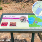
🧭 Key Point-of-Interest Directory
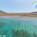
Landmark English Name Primary Features & Amenities 創興水上活動中心 Chong Hing Water Sports Centre An institutional aquatic centre offering kayaking, dinghy sailing, and windsurfing facilities for groups. 萬宜水庫 • 西壩 West Dam The western retaining wall of the reservoir, looking out across an expansive, calm inner lagoon and camp areas. 萬宜水庫 • 東壩 East Dam The core geo-site of the Geopark; a premier location for viewing ancient volcanic columns and capturing sunrises. 糧船灣 (High Island) High Island (Leung Shuen Wan) A former historic island, now connected to the mainland via the dams, rich in wave-cut geology and coastal trails. 白臘村 Pak Lap Village A peaceful indigenous village situated a short walk off the main road, adjacent to the sandy Pak Lap Wan beach. —
🌋 Geopark Wonders Deep Dive
🔶 Hexagonal Volcanic Columns
- Formed over 140 million years ago as a massive volume of volcanic ash and lava slowly cooled and contracted, creating incredibly uniform vertical columns.
- Reaching heights of up to 100 meters, this vast formation represents one of the most extensive and rare structural volcanic rock faces on Earth.
- Acts as the absolute crown jewel of the Hong Kong UNESCO Global Geopark.
🌊 Po Pin Chau Sea Stack
- A dramatic example of marine erosion where continuous wave pounding undercut a peninsula, eventually separating it into a freestanding sea stack with sheer cliffs.
- Accessible via a rugged dirt hiking track branching off the East Dam, giving views of adjacent sea caves and sea arches.
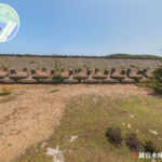
⚓ Interlocking Dolosse Breakwater
- A striking feat of coastal engineering consisting of thousands of massive, double-T anchor-shaped concrete blocks stacked along the outer oceanward wall.
- Engineered specifically to buffer the East Dam against the severe wave action and storm surges of the South China Sea.
—
🌄 Route Highlights & Trail Overview
🔹 Chong Hing Water Sports Centre
- Managed by the Leisure and Cultural Services Department (LCSD), this facility offers structured water sports training and day-camp activities for schools and community organizations.
🔹 High Island Geological Formations
- The area is internationally recognized as containing some of the most dramatic and structurally sound columns in Asia, often referred to by geology enthusiasts as a “natural rock mural.”
🔹 MacLehose Trail Stage 1
- The entirety of Sai Kung Man Yee Road serves as the paved opening stretch of this world-famous 100-kilometer trail system, delivering a smooth walk with sweeping water views.
🔹 Cultural Village Excursions
- Side paths drop down from the main road into historical village enclaves like Pak A, Tung A, and Pak Lap, where traditional rural architecture and ancestral heritage are still preserved.
—
🏗️ Historical Legacy & Construction
- Constructed throughout the 1970s, High Island Reservoir remains Hong Kong’s largest freshwater storage reservoir by volume.
- The roadway was initially built solely for heavy construction access, transforming later into an eco-tourism corridor for hikers.
- The official commissioning ceremony for the entire reservoir scheme was presided over by the Governor of Hong Kong, Sir Murray MacLehose.
🌟 Fun Trivia
- The Chinese name “Man Yee” (萬宜) carries the auspicious meaning of “all things being suitable,” reflecting the colonial government’s hopes for smooth engineering and a stable, long-term water supply.
- The outward-facing East Dam is widely celebrated among local landscape photographers as one of the finest spots in Hong Kong to view the ocean sunrise.
- The local rock column group is globally unique due to its acidic, silica-rich rhyolitic composition, distinguishing it from basic basaltic columns found elsewhere in the world.
—
📸 Photography Guide: Capturing the Best Shots
- East Dam Volcanic Walls: Head down in the early morning; the low-angled sunlight highlights the deep textures, joints, and curves of the columns beautifully.
- The Dolosse Seawall: Capture this from an elevated vantage point along the road to highlight the clean, repeating geometric patterns of the anchor blocks against the sea.
- Po Pin Chau Overlook: Use a telephoto lens from the high ridges of High Island to compress the frame, emphasizing the dramatic scale of the sea stack cleaved away from the mainland.
—