💧【Shui Long Wo (水浪窩)】 is located alongside Sai Sha Road in the Tai Po District, New Territories. Serving as the junction for Sections 3 and 4 of the MacLehose Trail, it is a serene enclave steeped in natural biodiversity and historical charm. Adjoining Ma On Shan Country Park, the area boasts a lushly vegetated environment and diverse flora and fauna, where egrets and butterflies are frequently seen fluttering about, while the surrounding mangroves and wetlands offer prime spots for observing coastal ecosystems. Shui Long Wo is not just a green oasis away from the urban hustle; its proximity to Port Shelter and Three Fathoms Cove shapes a unique coastal landscape that draws countless hikers and photography enthusiasts alike.
📌 Quick Facts
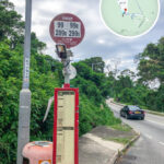
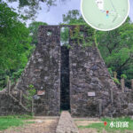
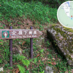
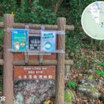
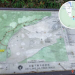
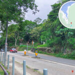
Item Detailed Information 🏞️ Location Name Shui Long Wo 📍 Region Shap Sze Heung, Tai Po District, New Territories, Hong Kong, adjacent to Sai Sha Road 🗺️ Geographical Position Junction of MacLehose Trail Sections 3 & 4, near Kei Ling Ha Lo Wai and the islands of the Sai Kung Channel; falls within the country park boundary 🧭 GPS Coordinates Approx. 22.408°N, 114.264°E 🌄 Natural Scenery Mountain vistas, ocean views, Three Fathoms Cove, dense woodlands, with distant views of Pyramid Hill and the Ngong Ping Plateau 🔭 Featured Landmark Shui Long Wo • Star Lookout: Modeled after an ancient Chinese astronomical observatory, standing 6 meters tall and enveloped by trees; a highly popular photo spot 🌳 Educational Trail Kei Ling Ha • Tree Walk: A short walking trail equipped with plant identification plaques, ideal for families and nature education 🚶♂️ Hiking Trails MacLehose Trail Section 3 (Pak Tam Chung to Shui Long Wo) and MacLehose Trail • Section 4 (Shui Long Wo to Tai Kong Po); the combined area covers challenging, rugged terrain 🏕️ Activity Types Hiking, outings, camping, stargazing, nature studies 🚌 Public Transport Take bus routes 99, 299X, or 289R from MTR Sha Tin Station or Wu Kai Sha Station, and alight at the Shui Long Wo stop; Route 99 can also be boarded from Sai Kung Town Centre 🚻 Facilities Public toilets (including accessible stalls), vending machines, water refilling stations, and an AFCD management post ⚠️ Important Notes Certain trail sections are steep and rugged, so non-slip footwear is highly recommended; insects are common in summer, so carry bug spray; please adhere to “Leave No Trace” principles to protect the environment 🧭 Target Audience Hiking enthusiasts, family outings, nature study groups, and photography lovers 📷 Photo Spots Star Lookout, Three Fathoms Cove coastal views, wooded pathways, and MacLehose Trail distance posts — The most prominent hallmark of this location is the ancient astronomical observation facility standing on site, known as the “Star Lookout.” Modeled directly after historic Chinese astronomical instruments, it sits strategically near Three Fathoms Cove. Historically, this area served as a crucial navigation landmark for local fishermen and mariners; today, it has evolved into a popular destination for visitors seeking to uncover local history and natural beauty. —
🌟 Top Attractions In-Depth
🧭 1. Shui Long Wo • Star Lookout
- Standing 6 meters high, it is modeled after the ancient astronomical observatory in Dengfeng, Henan Province.
- Enclosed by a lush canopy of trees, giving it a mysterious, timeless aura.
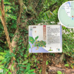
- Serves as the starting point for the Kei Ling Ha • Tree Walk, making it an excellent backdrop for photos.
🥾 2. MacLehose Trail • Sections 3 and 4
- Section 3: Runs down into Shui Long Wo, tracing past rugged peaks with sweeping views of Three Fathoms Cove.
- Section 4: Sets off from Shui Long Wo toward the Ngong Ping Plateau, offering majestic vistas tailored for intermediate hikers.
- Along the way, hikers can look out over the Sai Kung Channel and Tolo Harbour.
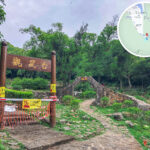
🌳 3. Kei Ling Ha Villages (Lo Wai and San Wai)
- Please maintain quiet and show respect to local residents when walking through the villages.
- The area features mangroves, wetlands, and pristine coastlines that feel like a hidden paradise.
🧺 4. Sham Chung • Grand Grassland
- Accessible via an approximate 1.5-hour walk from here.
- The lawn is private property; it is highly recommended to check with nearby village stores before settling in.
- A tranquil, idyllic environment perfectly suited for picnics and resting.
—
🚍 Transportation Guide
Starting Point Bus Route Alighting Station Sha Tin Station 299X Shui Long Wo Stop Wu Kai Sha Station 99, 289R Shui Long Wo Stop Sai Kung Town Centre 99 Shui Long Wo Stop Ma Liu Shui Kaito Ferry Sham Chung Pier Connects onward to Tap Mun or Ma Liu Shui — Beyond its historic relics, the natural environment surrounding Shui Long Wo is equally enchanting. Nestled close to Ma On Shan Country Park, it is enveloped by verdant woodlands and crystal-clear bays, offering numerous hiking paths and lookout points where visitors can soak in the grand views of Kei Ling Ha and Ma On Shan. The immense biodiversity here makes it a heavily favored hotspot for nature lovers and birdwatchers. —
🏞 Main Attractions & Natural Landmarks
Attraction Name Key Features & Highlights 🔭 Star Lookout A 6-meter-tall stone structure modeled after ancient observatories, surrounded by dense green forest 🌿 Tree Walk Begins at Kei Ling Ha, showcasing rich native flora; perfect for short, educational walks 🏕 Sham Chung Grassland A beautiful, rolling green lawn heavily favored for family picnics; note that it is private property 🌊 Three Fathoms Cove Stunning coastal vistas looking out toward Ma On Shan and Tolo Harbour 🪨 Sheung Lo Stream & Ha Lo Stream Natural stream courses along the trail that add a touch of outdoor adventure —
🚶♂️ Recommended Hiking Itineraries
🔹 Shui Long Wo → Sham Chung Route (Approx. 1.5 hours)
- Starting Point: Shui Long Wo Bus Station
- Route: Kei Ling Ha Lo Wai → Mangrove Wetlands → Sham Chung Grassland
- Endpoint: Sham Chung Pier (where you can catch a kaito ferry to Ma Liu Shui or Tap Mun)
- Features: Mostly paved concrete paths that are easy to walk, accompanied by gentle sea breezes; sun protection is recommended in summer.
—
🧭 MacLehose Trail Challenger Routes
- Section 3: Heading backward toward Pyramid Hill and Ngong Ping Plateau; requires steep climbing.
- Section 4: Setting off from Shui Long Wo toward Pak Tam Chung.
- Target Audience: Experienced hikers with good stamina who enjoy panoramic mountain ridges and long-distance trekking.
—
📝 Tips & Safety Advice
- 🦟 Mosquito Protection: Insects thrive here during the summer months; carrying effective insect repellent is highly recommended.
- ☀️ Sun Protection & Hydration: Certain stretches offer little to no canopy shade; ensure you apply sunblock and carry ample drinking water.
- 👟 Proper Gear: Non-slip hiking shoes are recommended as some off-road trails can be loose and rugged.
- 🗑️ Environmental Preservation: Strictly adhere to “Leave No Trace” principles and pack out all of your trash.
—
🌟 Curated Attraction Highlights
Attraction Name Detailed Description 🔭 Star Lookout A 6-meter stone tower reflecting ancient Chinese architectural styles; surrounded by woods, it is excellent for stargazing and astrophotography. 🥾 MacLehose Trail The core intersection of Sections 3 and 4, unveiling spectacular vistas of Three Fathoms Cove, Pyramid Hill, and the Ngong Ping Plateau. 🌳 Tree Walk Sited at Kei Ling Ha, this short educational path is ideal for families, beginners, and nature identification studies. 🌿 Sham Chung Grassland A picturesque lawn perfect for relaxing, though visitors should respect its status as private land and check local store guidelines. 🏞️ Natural Streams Beautiful seasonal stream beds running alongside the trail paths, adding refreshing sights to your trek. —
🚶♂️ Leisure vs. Advanced Route Comparison
🔹 Beginner Route (Approx. 1.5 hours)
Shui Long Wo → Kei Ling Ha Lo Wai → Sham Chung Grassland → Sham Chung Pier
- Consists primarily of flat, paved concrete pathways.
- Offers easy access to view coastal mangroves and the broad seascape of Tolo Harbour.
- Perfect for families, couples, and casual photography lovers.
🔸 Advanced Route (Approx. 3–4 hours)
Shui Long Wo → Pyramid Hill → Ngong Ping Plateau → MacLehose Trail Section 4
- Features steep, unpaved mountain trails that demand excellent physical fitness.
- Rewards trekkers with grand, unhindered views looking down across the Sai Kung islands.
- Tailored for seasoned hikers.
—
🧰 Available Amenities & Facilities
- Public toilets located near the main entrance.
- Vending machines and public water-refilling stations.
- A small public parking lot (spaces are highly limited).
- A public barbecue site situated near the shorefront.
- Local village stores (typically open Friday through Sunday and public holidays, serving local snacks like tofu pudding).
—
📸 Photography Tips
Target Location Recommended Time Visual Features Star Lookout Early Morning / Twilight Captures dramatic sunbeams breaking through the trees against the stone structure Sham Chung Grassland Mid-Afternoon Vibrant green lawns set against coastal blue waters and dense mangroves Tolo Harbour Shoreline Just before Sunset Stunning reflections on the water with Ma On Shan silhouetted in the background —
🧭 Extended Exploration
- From Sham Chung Pier, visitors can catch a kaito ferry directly to Tap Mun or Ma Liu Shui.
- The Ngong Ping Plateau provides trail links extending deep into Ma On Shan Country Park.
- Routes can easily be stitched together to connect with larger networks stretching toward Sai Kung or Pat Sin Leng.
—