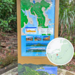
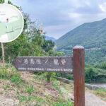
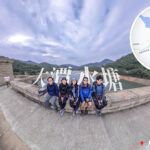
🐸 【Hong Kong Trail】 is a long-distance hiking trail stretching around 50 kilometres. Launched in 1985, it is divided into 8 sections and spans across the entirety of Hong Kong Island, kicking off from The Peak on the western end and wrapping up at Big Wave Bay in the southeast. It strings together city skylines, mountain ridges, streams, historic reservoirs, and spectacular coastal landscapes. The biggest highlight of this route is the ability to step away from the bustling city and dive right into the natural wilderness within just a few hours, experiencing a sharp contrast between “the urban and the wild”. The Hong Kong Trail is not only one of Hong Kong’s four major long-distance trails, but was also selected by *Lonely Planet* in 2013 as one of the “Top 10 Best Urban Hiking Trails” in the world. Along the way, you can take in the panoramic night views of Victoria Harbour from Lugard Road , the century-old classical dam structures of the Tai Tam Reservoir , and the world-famous coastal ridge of the Dragon’s Back . It serves as a go-to weekend leisure option for locals and stands as one of the best routes for international travellers to explore Hong Kong’s nature and culture.
📌 Quick Facts
Item Information 🗺️ Location Hong Kong Island, from west to east 📏 Total Length Approx. 50 km 🔢 Sections 8 sections 📅 Year Opened 1985 🌄 Highlights Combines city skylines, mountain ridges, streams, historic reservoirs, and coastal views 🌍 Global Recognition Ranked 10th on *Lonely Planet’s* “Top 10 Best Urban Hiking Trails” list in 2013 —
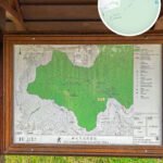
🗺️ Detailed Section-by-Section Guide
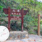
Section Start → Finish Distance Time Required Difficulty Scenic Highlights Section 1 The Peak → Pok Fu Lam Reservoir 8 km 2–2.5 hr ⭐️ Panoramic views of Victoria Harbour from Lugard Road Section 2 Pok Fu Lam Reservoir → Peel Rise 6.5 km 1.5–2 hr ⭐️ Slopes of Mount Kellett, sweeping views of Aberdeen Typhoon Shelter Section 3 Peel Rise → Wan Chai Gap 7.5 km 2–2.5 hr ⭐️ Shaded dirt paths, catchwater slopes of Tin Wan Shan, streams and mini waterfalls Section 4 Wan Chai Gap → Wong Nai Chung Gap 9.5 km 2–2.5 hr ⭐️⭐️ Lady Clementi’s Ride, packed with WWII military relics along the way Section 5 Wong Nai Chung Gap → Mount Parker Road 4.5 km 1.5–2 hr ⭐️⭐️⭐️ A challenging climb over Jardine’s Lookout and Mount Butler Section 6 Mount Parker Road → Tai Tam Road 6.5 km 2–2.5 hr ⭐️⭐️ Century-old classical masonry dam clusters of the Tai Tam Reservoir Section 7 Tai Tam Road → To Tei Wan 9 km 2–2.5 hr ⭐️⭐️ Flat walk along the catchwater, passing by Obelisk Hill Section 8 To Tei Wan → Big Wave Bay 9.5 km ~3–3.5 hr ⭐️⭐️⭐️⭐️ Stunning coastal views along Dragon’s Back, panoramic views of Shek O from Shek O Peak —
✨ Geographical & Cultural Highlights
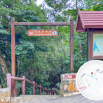
- Mountains and Seas Blended: The western sections sit close to the city, offering bird’s-eye views of Victoria Harbour, while the eastern sections show off epic coastal skylines.
- Rich Biodiversity: Covers woodlands, streams, shrublands, and coastal bays, nurturing a wide variety of flora and fauna.
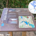
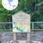
- Cultural Heritage: Keep an eye out for WWII pillboxes, stone-paved catchwaters, boundary stones, and other historic relics along the trail.
- Easy Escape: Every section has clear exit points, making it incredibly flexible to complete the trail piece by piece.
- Balanced Difficulty: The first half is relatively flat and beginner-friendly, while the second half (Jardine’s Lookout, Dragon’s Back) gives you a proper workout.
—
🚶♂️ Who Is It For?
- Beginners / Families: Sections 1–3 feature shorter distances and well-maintained facilities.
- Thrill Seekers: Section 5 (Jardine’s Lookout and Mount Butler) and Section 8 (Dragon’s Back) are the absolute standouts.
- Photography Enthusiasts: The Victoria Harbour night views from Lugard Road, the coastal vistas along Dragon’s Back, and the stunning ridges of Mount Butler are perfect for snapping shots.