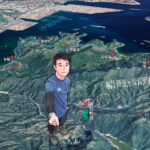
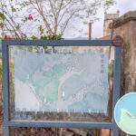
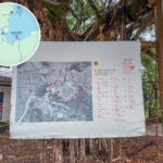
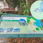
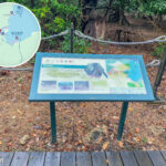
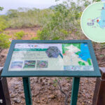
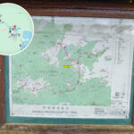
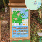
🗺️ 【Hiking Information Boards】are crucial navigational guides for hikers on Hong Kong’s country park trails. Usually installed at trailheads, major junctions, or recreation areas, these information boards clearly display route maps, distances, terrain profiles, and surrounding attractions, allowing hikers to master their orientation and time management. They serve not only as navigation tools but also as safety nets, reminding visitors about weather conditions, first-aid facility locations, and emergency contact methods. Beyond their practical functions, these trail maps also tell the stories of Hong Kong’s nature and culture. Many boards highlight ecological features, historical relics, or iconic landmarks along the way, such as Lion Rock and Tai Mo Shan, enriching hikers’ journeys with cultural meaning alongside the scenic views. They act as the “storytellers at the gateway” of our trails, unveiling an exploration journey that blends nature and heritage before every departure.—
📌 Basic Structure
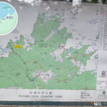
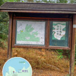
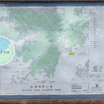
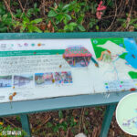
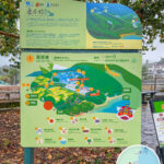
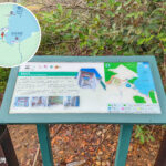
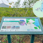
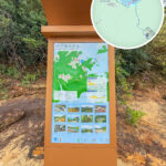
Section Functions & Contents Examples 📍 Header Area Clearly displays the name of the trail Lantau Trail 🗺️ Main Map A colourful topographical map marking routes, intersection points, and major landmarks Shing Mun Reservoir, peaks, junctions 📑 Legend Section Displays amenities and facilities using symbols 🚻 Toilets · 🛖 Pavilions · 🔥 Barbecue Sites · 💧 Water Filling Stations 📖 Text Description An overview of the trail’s length, difficulty, estimated time, and natural features e.g., Total Length: 10 km · Medium Difficulty · Estimated Time: 3 hours · Scenic woodlands and streams along the way —
🌿 Design Features
- Environmental Integration: Timber or stone frames that blend seamlessly with the surroundings to avoid disrupting the natural beauty.
- Weather-resistant Materials: UV-resistant and waterproof coatings that protect against sun damage, ensuring information remains clear over the long term.
- Multilingual Design: Chinese and English presented side-by-side, with Pinyin/romanisation added for certain locations to assist overseas tourists.
- Educational Illustrations: Features flora, fauna, or geological illustrations to enhance interest and recognition (e.g., Sai Kung volcanic rocks ).
- Interactive Extensions: Includes QR codes linking to the “Enjoy Hiking” website or mobile application.
—
🚶♂️ User-Oriented Features
- Positioning Function: The map design aligns with the “Enjoy Hiking” App for easy cross-referencing.
- Graded Difficulty: Uses colours or symbols to indicate route difficulty, helping visitors choose a suitable trail.
- Safety Reminders: Reminds hikers to bring enough drinking water, avoid single-use items, and take their litter home.
- Cultural Connections: Highlights historical relics along the way (e.g., wartime relics on the Wilson Trail).
—
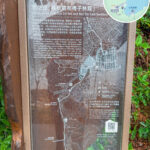
1️⃣ Map Design
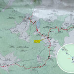
- Panoramic Route Maps: Displays the entire trail using a simplified topographical map, marking key landmarks (such as 🗻 Lion Rock and 🌊 Tai Long Wan).
- “You Are Here” Marker: Clearly points out the visitor’s current location to prevent them from getting lost.
- Colour-coded Sections: Different trail sections are distinguished by colours for easy identification of difficulty and direction.
—
2️⃣ Route Information
- Distance & Time: Marks the mileage and estimated walking time, using common formats like “Total Length: 5 km, takes approx. 2 hours”.
- Difficulty Rating: Displayed via symbols or colours (e.g., Green = Easy, Red = Highly Challenging).
- Elevation Profile: Some boards include a simple elevation cross-section graph showing uphill and downhill distributions.
—
3️⃣ Safety & Environmental Reminders
- 🚰 Hydration Reminder: Advises hikers to carry a sufficient supply of fresh water.
- 🗑️ Pack It Out: Emphasises the local eco-slogan “Take Your Litter Home”.
- ☀️ Sun & Mosquito Protection: Reminds visitors to use sunscreen and apply mosquito repellent.
- 📵 Emergency Contacts: Displays emergency hotlines and the nearest exit locations.
—
4️⃣ Transport & Facilities
- 🚌 Transport Connections: Marks the nearest bus stops or green minibus (GMB) stands.
- 🛖 Recreational Facilities: Locations of pavilions, toilets, and barbecue sites.
- 🚶 Alternative Routes: Provides alternative path options, allowing visitors to adjust their itineraries easily.
—
5️⃣ Multilingual & Educational Functions
- Bilingual English & Chinese: All place names are paired with English, such as Shing Mun Reservoir.
- Ecological Interpretations: Introduces common flora and fauna found along the trail (such as Horsetail Tree and Black-faced Spoonbill).
- Cultural Background: Certain routes feature historical stories, such as the connection between Lantau Peak and Buddhist culture.
—
📍 Common Layout of Information Boards
Location Content Key Features 🚩 Trailhead (Start) 🗺️ Full route map, 🚌 Transport options 📍 “You Are Here” marker ⛰️ Mid-trail 🔀 Intersections, 🛖 Rest stops 🛖 Pavilions, 🚻 Toilet locations 🌄 Scenic Spots 🌿 Natural / 🏯 Cultural commentaries e.g., ⛰️ Tai Mo Shan 🏁 End Point 🚍 Return transport info ⚠️ Safety alerts, ♻️ Recycling and litter reminders