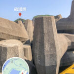
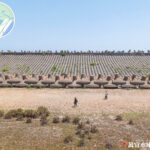
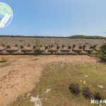
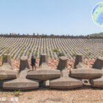
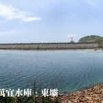
🚶🏻➡️【High Island Geo Trail (萬宜地質步道)】 is the core route of the Hong Kong UNESCO Global Geopark. Spanning about 3.3km, it is located at the East Dam of the High Island Reservoir in Sai Kung. Along the trail, you can get up close and personal with world-class hexagonal volcanic columns, fault breccia zones, twisted rock columns, and spectacular sea caves—all jaw-dropping landforms left behind by a massive super-volcanic eruption 140 million years ago. The absolute star of the show here is the Hexagonal Volcanic Columns. Towering up to 100 meters high and neatly lined up like a colossal stone wall, their sheer scale is mind-blowing, making it a true world-class geological wonder.
📌 Quick Facts
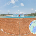
Item Details 🗺️ Location East Dam, High Island Reservoir, Sai Kung 📏 Length Approx. 3.3km ⏱️ Time Around 2–3 hours’ walk 🧗 Difficulty Easy to moderate; perfect for hiking beginners 🌍 Highlights A core route of the Hong Kong UNESCO Global Geopark, featuring world-class volcanic rock formations that showcase spectacular landscapes formed by a super-volcanic eruption 140 million years ago —
🌋 Geological Background
- Around 140 million years ago, a super-volcanic eruption rocked Hong Kong, creating a massive expanse of volcanic tuff.
- As the lava cooled down, it contracted and cracked into incredibly neat Hexagonal Rock Columns that loom up to 100 meters high.
- Over the eons, wave erosion, weathering, and crustal movements further sculpted this dramatic coastal landscape.
—
— Walking along this trail, visitors can not only check out fault breccia zones, curved columns, and sea caves at close range, but also hit up the viewing points to look down on the breathtaking coastlines of Long Ke Wan and Po Pin Chau. It is both a goldmine for geologists and a total paradise for shutterbugs—making it the ultimate starting point to uncover Hong Kong’s natural and cultural stories. —
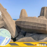
🌋 Geological Features
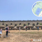
- 🟦 Hexagonal Volcanic Columns
- Looming up to 100 meters tall, with an average diameter of about 1.2 meters.
- Covering an area of over 100 square kilometers, stretching all the way into the seabed.
- A world-class geological wonder formed by the cooling and contraction of lava after the mega eruption.
- 🪨 Fault Breccia Zone
- Created by rocks being crushed and ground together during tectonic movements.
- Squeezed right between the rock columns; keep your eyes peeled for the info signs along the trail to spot them.
- 🔄 Curved Columns
- Bentu into striking S-shapes, looking just like a natural mural.
- How they formed: The lava was warped by tectonic shifts before it could completely solidify.
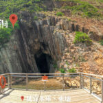
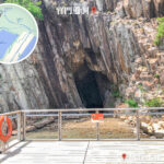
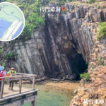
- 🌊 Sea Caves & Sea Stacks
- Carved out by relentless wave action over centuries, showcasing a rugged and dramatic coastal landscape.
—
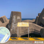
🗺️ Trail Highlights
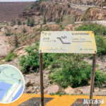
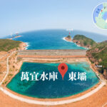
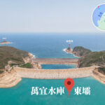
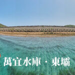
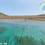
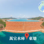
- 🏛️ Starting Point: East Dam Memorial Monument
- The kickoff point of the trail, built to honor the workers who lost their lives constructing the reservoir back in the 1979 project.
- Marked by a giant blue anchor stone right next to it.
- The breakwater is made up of over 7,000 interlocking dolosse blocks, looking absolutely epic.
- 🌄 Biu Tsim Kok Viewing Point
- An extension path that adds about 1km to your walk.
- Offers stunning bird’s-eye views of Long Ke Wan, Po Pin Chau, and the Ninepin Group (Kwo Chau Islands).
- Serves up a killer 270 to 360-degree panorama—hands down the best spot for photos.
- 🪨 Po Pin Chau
- Originally connected to Fa Shan, this massive islet was sliced off by severe sea erosion, creating an iconic sight.
- Rising vertically straight out of the ocean, the cliff face looks incredibly majestic.
- Constant wave bashing over the years has hollowed out caves and left this standalone sea stack.
—
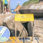
🚍 Transport Info
Mode of Transport Details 🚌 Minibus Route 9A, running between Pak Tam Chung ↔ East Dam (operates on weekends and public holidays only). 🚖 Taxi A green or red cab from Sai Kung Town Center straight to the East Dam will cost you around HKD $150. —
⚠️ Things to Note
- There is practically zero shade along the trail, so make sure you smash on the sunscreen and wear a hat.
- Be sure to respect the “Hong Kong Geopark Code”:
- Strictly no graffiti and do not take any rocks away.
- Stay well away from cliff edges to prevent any accidents.
🕒 Best Timing + Suggested Itinerary
🕒 Best Start Time 📋 Suggested Itinerary 9:00 AM – 10:00 AM Head out from Sai Kung Town Center and grab a minibus or taxi straight to the East Dam. The morning sun is nice and soft—perfect for capturing the volcanic columns. Around Noon Arrive at the Memorial Monument and track along the trail to admire the Hexagonal Volcanic Columns and the Fault Breccia Zone. Don’t forget your sun protection gear! 1:00 PM – 2:00 PM Make your way up to the Biu Tsim Kok Viewing Point to gaze down at Long Ke Wan and Po Pin Chau. This is the absolute prime time for epic shots. 3:00 PM – 4:00 PM Head back down to the East Dam to wrap up your hike. If you’ve still got energy, head back into Sai Kung Town Center for a massive seafood dinner to top off a perfect day. —
🧭 Handy Tips
- Transport: On holidays, you can hop on the 9A minibus from Pak Tam Chung to the East Dam; on weekdays, your best bet is catching a taxi from Sai Kung.
- Supplies: There are no shops or kiosks along the trail, so make sure you stock up on food and plenty of drinks at Sai Kung Town Center before you leave.
- Safety: The trail is completely exposed with no tree cover, so watch out for sunburn. Never get too close to the cliff edges or attempt to climb the rock columns.
- Eco-friendly: Take nothing but photos. Do not pocket any rocks or deface the geological formations—let’s keep nature pristine.