🚶🏻➡️【Lion’s Tail Ridge Path (獅尾脊徑)】 is a highly challenging, unofficial hiking route located on the southeastern side of Lion Rock. It is famous for its rugged rock formations, a blend of natural scenery, historical relics, technical scrambling challenges, and breathtaking panoramic views of the city. Although it is an unmaintained path, it remains a major favorite among experienced local hikers. Starting from Fat Jong Temple in Tsz Wan Shan, hikers must tackle a grueling incline of nearly 300 meters in elevation to reach the peak of Lion Rock. The most iconic landmarks along the trail include the “Sky Ladder Rock,” which requires some serious hands-on scrambling, and the ruins of the “Fool’s Tower,” built by five elderly hikers back in 1959. Although the tower has collapsed, the remaining six-story concrete structure and the inscribed couplet—”Two hills embrace the sea where carps swim free; one tower pierces the sky to wake the sleeping lion”—stand as a testament to the creators’ original vision of awakening the sleeping lion. —
— The entire Lion’s Tail Ridge route is around 3 km long and takes about 3 to 4 hours to complete. Roughly 60% of the trail requires scrambling over exposed rock faces. This is especially true at Sky Ladder Rock, where hikers can choose to tackle it head-on (the toughest variation), climb up the natural rock steps on the right, or take a detour. Even though it is not an official path, the ribbon markings along the way are pretty clear. Once you reach the top, you will be rewarded with jaw-dropping views of Victoria Harbour, the Kowloon Peninsula, and Hong Kong Island. On a clear day, you can even see all the way to Fei Ngo Shan and Beacon Hill. Because certain sections run right along the cliff edge and require solid physical fitness, this route is only recommended for seasoned hikers in groups. Wearing gloves and shoes with good grip is highly recommended, and you should definitely skip this challenge on rainy or foggy days. To head back down, you can connect to the MacLehose Trail towards Kowloon Pass, or take the Lion Rock Ancient Trail to visit Amah Rock, wrapping up a unique journey that beautifully blends natural wonders with historical traces. —
🗺️ Route Overview
Item Details Start Fat Jong Temple, Tsz Wan Shan End Lok Fu or Kowloon Pass Distance Approx. 2.86–3.5 km Duration Approx. 3–4 hours Difficulty Intermediate to Advanced (requires hands-on scrambling) Elevation Min. 84 m, Max. 425 m, Total Ascent approx. 322 m Scenery Kowloon Peninsula, Victoria Harbour, Hong Kong Island, Fei Ngo Shan —
🧭 Itinerary & Route
- Fat Jong Temple: The starting point is located right next to Shatin Pass Road. You can take green minibus 18 from Wong Tai Sin Station to get here.
- Transmission Tower: After passing the first pylon, the trail starts getting rough and rugged.
- Sky Ladder Rock: A steep, technical scrambling section made up of massive stacked boulders.
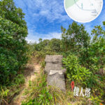
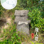
- Fool’s Tower: Built in 1959, only the foundation and inscriptions remain today.
- Lion’s Tail: The terrain gets incredibly steep here before joining the main Lion Rock trail.
- Lion’s Head: Offers a stunning view of Kowloon and Victoria Harbour; a top spot for photos.
- Kowloon Pass: From here, you can head down towards Lok Fu or continue towards Beacon Hill.
—
🚍 Getting There & Away
- To the Start: Take Green Minibus 18 (from Wong Tai Sin Station Exit E) and get off at Fat Jong Temple.
- From the Finish: Take Green Minibus 53M (from Tin Ma Court to Lok Fu Station).
—
📷 Recommended Photo Spots & Scenic Highlights
- ⛩️ Fat Jong Temple: The starting point next to Shatin Pass Road, easily reached by minibus 18 from Wong Tai Sin Station.
- 🪨 Sky Ladder Rock: A spectacular, massive pile of stacked boulders—great for low-angle dramatic shots.
- 🏞️ Lion’s Tail Ridge Peak: Overlooking the Kowloon Peninsula, Victoria Harbour, and Hong Kong Island; views stretch out to Fei Ngo Shan and Beacon Hill. Looking the other way, you can see Sha Tin, the Sha Tin Racecourse, and all the way out to Tolo Harbour and the Shuen Wan Plover Cove Reservoir.
- 🗿 Fool’s Tower Ruins: Built in 1959 with inscribed poems, only the foundations remain today, giving off a strong sense of history and wilderness vibes.
- 🌄 Sunset: The interplay of light and shadow here creates an incredible atmosphere.
—
🏛️ History of Fool’s Tower
The tower was built by Tsang Wai-sue, Lai Shui-pui, Chan Yat-kuen, Chan Po-shing, and Miu Chi-choo. Standing about 15 feet tall and tapering off towards the top, it symbolized the ambition to “awaken the sleeping lion.” The inscriptions note: “To patch up the sky and fill the sea, where there’s a will there’s a way… it is simply to awaken the sleeping lion.” Dubbed the “Fool’s Tower,” it was a bold challenge to conventional societal values and a symbol of pure spirit.
—
🧠 Cultural Significance of Lion’s Tail Ridge
Lion’s Tail Ridge embodies the local “Lion Rock Spirit”—perseverance, resilience, and mutual help. The creators of Fool’s Tower, with their sheer determination to “patch the sky and fill the sea,” built this structure right on the mountain, perfectly reflecting this legendary Hong Kong attitude.
—
🧤 Recommended Gear & Safety Tips
Recommendation Details 🧤 Gloves To protect your hands during heavy rock scrambling. 🗺️ Maps The trail is unmaintained and unofficial; it is very easy to lose your way. 🥾 Hiking Shoes Must have strong grip, essential for rocky terrains. 🧭 Companions Highly recommended to hike with someone experienced. 🌤 Weather The dry, cool autumn and winter months are the absolute best. 🚫 Danger Zones Several sections run right along cliff edges with no guardrails whatsoever. Watch your step when taking photos—safety first! 🧴 Sun Protection The sun can be brutal at the ridge and summit. 💧 Water Zero replenishment points along the route. 🔦 Headlamp Just in case your schedule gets delayed into the evening, this will ensure you get down safely. —
⚠️ Pre-trip Preparation
- ✅ Pack plenty of water and energy snacks.
- ✅ Check your maps and route info thoroughly beforehand.
- ✅ Let family or friends know your itinerary and estimated return time.
- ✅ Fully charge your phone and download offline maps.
- ✅ Avoid going solo—hike in groups for a safer journey.
—
📚 Further Exploration
- 🧭 Lion Rock Main Peak: Connects further to Beacon Hill or Kowloon Pass.
- 🌿 Sha Tin Pass Road: Leads down to Tsz Wan Shan and Wong Tai Sin.
- 🏞️ Fei Ngo Shan: Higher elevation with even grander, sweeping views.
— If you are interested in this route, feel free to check out 《 Lion’s Tail Ridge • Daydreamer 》. —