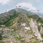
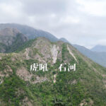
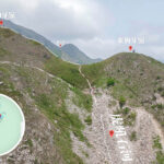
🐯【Roaring Tiger Rock River (虎吼石河)】 is located on the upper reaches of Middle Kau Nga Ling, nestled between Middle Kau Nga Ling and East Kau Nga Ling on Lantau Island. The name stems from the soaring cliffs flanking the scree slope, which resemble two tigers facing off in a dramatic standoff, as well as the rumbling, thunderous roar echoed down the valley when loose rocks come cascading down. Formed by fragments of conglomerate rock that have fractured, weathered, and collapsed down the ravine over centuries of intense wind and rain, this scree field stretches about 80 meters long. Blanketed with loose rocks of all shapes and sizes, it is a legendary yet highly treacherous territory for Hong Kong hikers, notorious for its exhausting “one step forward, two steps back” terrain. —
—
📌 Quick Facts
Category Details 🌍 Location Southern part of Lantau Island, Hong Kong, situated on the upper reaches of Middle Kau Nga Hang between Middle and East Kau Nga Ling. 🐯 Name Origin The surrounding cliffs resemble two tigers facing off, and the rumbling sound of shifting boulders mimics a tiger’s roar, hence the name “Roaring Tiger Rock River”. 🪨 Geological Formation Continuous weathering and erosion caused massive rock faces to fracture, shedding loose debris that accumulated into a scree slope over 100 meters long. 🏞️ Terrain Characteristics A wide, highly unstable slope covered in loose stones and boulders; exceptionally steep, requiring scrambling on all fours. 📏 Trail Length Approximately 6–7 km, depending on the chosen exit route. ⏱️ Duration Around 6–6.5 hours, including technical climbing segments and necessary rest stops. 📈 Elevation Change An overall ascent of roughly 571 meters and a descent of 481 meters, featuring rolling and rugged terrain. 🧗♂️ Difficulty Rating ⭐️⭐️⭐️⭐️⭐️ (Extreme Challenge), strictly suited for highly experienced hikers and scramblers. 🧭 Route Overview Shui Hau Village → Catchwater → Middle Kau Nga Hang → Fu How Shek Ho → Kau Nga Ling → Lifeline (A Line of Life) → Yim Wong Pik (Hades’ Wall) → Tsam Chai Au → Ngong Ping 🌄 Major Highlights Fu How Shek Ho Scree Field | The Two Tigers Standoff Cliffs | Lifeline (Chain-assisted scramble) | Yim Wong Pik (Near-vertical rock wall) 🚌 Inbound Transport Take NLB Bus Route 11 or 23 from Tung Chung and alight at Shui Hau Village. 🛑 Outbound Transport Take a bus from Pak Kung Au back to Tung Chung, or head out via public transport from Ngong Ping. 🥾 Recommended Gear High-traction hiking boots, protective gloves, trekking poles, a reliable headlamp, and an ample supply of water and trail snacks. ⚠️ Vital Warnings Never attempt in wet weather (the rock river becomes treacherous) | The path is poorly defined and requires ribbons or GPS tracking | Absolutely not recommended for novices or solo hikers. 🚫 Supplies & Exits No replenishment points along the entire route; hikers can make an emergency exit toward the Lantau Trail via the “Bucktooth Rock” (Sio Nga Shek). —
🏞 Landscape & Name Origin
The formation of Fu How Shek Ho is the result of long-term weathering and geological erosion. The steep rock walls flanking Middle Kau Nga Hang continuously fracture due to thermal expansion from day-night temperature swings and heavy downpours, causing boulders to shatter and accumulate into a massive scree slope. The deep, low-frequency rumbling of shifting rocks rolling down the gorge sounds exactly like a roaring tiger, which inspired the dramatic name “Fu How Shek Ho.” —
🚌 Transport Information
Inbound Transport Outbound Transport NLB Bus 11 / 23 to Shui Hau (East) NLB Bus 23 from Ngong Ping back to Tung Chung — The classic approach to Fu How Shek Ho typically kicks off from Shui Hau Village, tracking along the catchwater before cutting up into Middle Kau Nga. The stream trek through Middle Kau Nga Hang is a formidable challenge in its own right, presenting slick, wet rock faces alongside several steep slopes that require careful technical ascents. Scaling the rock river demands true three-point contact (hands and feet), and climbers must stay highly alert to the constant risk of loose rocks dislodged from above, making this an elite-level route completely unsuited for beginners. —
🧭 Detailed Route Breakdown
1️⃣ The Start: Shui Hau Village → Lantau Trail Section 10
- Walk along South Lantau Road heading toward Tong Fuk.
- Turn left onto the mountain trail to join Section 10 of the Lantau Trail.
- Follow the catchwater channel and keep a close eye out for the entry marker near “Intake No. 5 Left Tooth”.
2️⃣ The Middle: River Trekking up Middle Kau Nga Hang
- Drop into Middle Kau Nga Hang and begin your upstream scramble.
- Negotiate technical sections like the Withered Gallery Wall, hidden waterfalls, and tight crevices between massive boulders.
- As the water volume tapers off, the terrain transitions into an open, rocky debris slope.
3️⃣ The Crux: Fu How Shek Ho (The Rock River)
- Enter the 100-meter scree slope where the loose gravel requires all fours to ascend safely.
- Take in the imposing cliff faces framing the slope like two dueling tigers while watching for shifting rocks.
- Route Tip: Sticking closer to the center line often yields slightly more stable footholds.
- Mind the extreme danger of falling rocks; maintain a safe distance and avoid clustering together.
4️⃣ The Final Climb: Kau Nga Ling → Lifeline → Yim Wong Pik
- Regain the mountain ridge trail and turn left to tackle the knife-edge gap known as the “Lifeline,” using the installed chains for stability.
- Push through the punishing incline of “Yim Wong Pik” (Hades’ Wall), which demands extreme focus and careful climbing.
5️⃣ The Finish: Tsam Chai Au → Ngong Ping
- Reach the high junction at Tsam Chai Au, then follow the standard Lantau Trail down into Ngong Ping to conclude your journey.
— While scaling Fu How Shek Ho is undeniably gruelling, the rewards are majestic panoramic views stretching out to the Soko Islands (Tai A Chau and Siu A Chau), alongside striking perspectives of East and Middle Kau Nga Ling. After conquering the core scramble, you can cross the thrilling gaps of the Lifeline and Yim Wong Pik to top out at Tsam Chai Au, then link back to the main Lantau Trail down to either Ngong Ping or Pak Kung Au. Alternatively, advanced hikers sometimes opt to loop back down via the ridges of East or Middle Kau Nga. For logistics, start by riding NLB Bus 11 or 23 from Tung Chung Town Centre to the Shui Hau Village (East) stop. At the end of the day, you can choose to take the Ngong Ping 360 cable car straight down to Tung Chung, or catch Bus 11, 23, or 3M from Pak Kung Au to return to the town center. —
🧬 Geological Formation & Terrain Features
- The Cause:
- Long-term wind and rainwater erosion coupled with sharp day-and-night temperature shifts cause the exposed cliff faces to split and fracture.
- The detached boulders succumb to gravity and plunge into the ravine, creating a dynamic rubble field over 100 meters long.
- Terrain Highlights:
- The slope is composed of highly unstable conglomerate rocks of varying sizes that shift underfoot.
- The flanking rock walls tower sharply over the route, providing a dramatic visual that mimics two stalking tigers.
—
🌟 Featured Trail Highlights
Attraction Description 🪨 The Scree River A daunting 100-meter slope of loose boulders requiring full-body scrambling; the ultimate test of balance. 🐅 The Two Tigers Cliffs The towering rock walls on either side of the river bed, offering a jaw-dropping, primal wilderness backdrop. 🧵 The Lifeline A razor-thin ridge section equipped with safety chains, widely regarded as the most exposed and technical segment of the route. 🧱 Yim Wong Pik (Hades’ Wall) A punishingly steep, near-vertical dirt and rock face that demands strong stamina and solid climbing technique. —
⚠️ Essential Safety Notes
- ✅ Always tackle this route alongside highly experienced scramblers, mountaineers, or local guides.
- ✅ Ensure you wear high-traction technical hiking shoes, pack protective gloves, and carry plenty of water and emergency rations.
- ❌ Never attempt during or immediately after rain; wet rock beds turn incredibly slick and dangerous.
- ❌ Absolutely off-limits for beginners; several segments present real exposure and serious technical challenges.
- 📵 The path is heavily overgrown and poorly marked, requiring reliance on ribbons or reliable offline GPS tracks for navigation.
—
🎒 Recommended Packing Checklist
- Sturdy scrambling boots and durable, grippy gloves
- A reliable headlamp or flashlight (with spare batteries)
- Offline topographic maps or a dedicated GPS navigation unit
- High-energy trail snacks and at least 2 to 3 liters of water
- A compact first-aid kit and sun protection gear
- A heavy-duty waterproof backpack or a robust rain cover
—
🧠 Pro Tips
- When tackling the loose scree of Fu How Shek Ho, keep your steps light and deliberate to minimize the chance of triggering a major rock slide.
- Spread out your group vertically and avoid hiking directly underneath one another to prevent injuries from falling debris.
- If you find your energy lagging or weather closing in, make a timely strategic exit at the Bucktooth Rock intersection to escape the ridge safely.
—