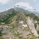
🐶 【Middle Kau Nga Hang (中狗牙坑)】 is a highly challenging mountain stream located south of Lantau Peak on Lantau Island, Hong Kong. It sits nestled in the valley between Middle Kau Nga Ling and East Kau Nga Ling. This stream is widely famous for its headwater wonder known as the Roaring Tiger Rock River. This rock river is a scree slope extending over 100 metres long, formed by the long-term weathering and collapse of mountain conglomerate rocks; when the loose rocks slide down, they produce a rumbling sound akin to a roaring tiger, and given that the cliff walls on both sides look like facing tigers, it earned this dramatic name. The entire stream route starts from the Shiu Hau Village catchwater and runs all the way up to the ridge of Kau Nga Ling, requiring hikers to scramble between dense trees and steep rock faces, making it a high-difficulty stream trekking route.
📌 Key Information
Item Details 📍 Location Southern part of Lantau Island, Hong Kong; located along the middle section of Kau Nga Ling, a southern ridge branch of Lantau Peak 🗺️ GPS Coordinates 22°14′31.79″N, 113°55′2.59″E ⛰️ Altitude Around 539 metres, which marks the highest point of Kau Nga Ling 🐾 Terrain Features Narrow ridges, heavily weathered rocks, and loose scree scattered everywhere; some sections are only wide enough for one person to pass, known as the Single Lifeline 🐯 Roaring Tiger Rock River An upstream scree slope roughly 80 metres long, flanked by cliff faces that resemble confronting tigers; the rumbling sound of loose rocks sliding down mimics a tiger’s roar 🧗♀️ Hiking Difficulty Classified as a high-difficulty route that requires scrambling up massive boulders and steep cliffs; strictly for experienced climbers 🚫 Supplies & Retreat No supply points along the way and no quick escape routes; hikers must bring their own water and dry rations, and pay close attention to weather conditions ⚠️ Safety Tips Never attempt the route during rain or thunderstorms; loose scree is highly unstable and slippery; there have been fatal accidents involving hikers slipping down the cliffs at the Single Lifeline 🧭 Suggested Route Start: Shiu Hau Village → Roaring Tiger Rock River → Kau Nga Ling → Single Lifeline → Yim Wong Pik → The Bird Rock → Tsam Chai Au → End: Ngong Ping 🚌 Transport Start: Shiu Hau Village (Bus 1, 2, 11, 23) | End: Ngong Ping (Bus 23) 📸 Scenic Highlights Offers panoramic bird’s-eye views of the Shek Pik Reservoir and the Lantau Peak mountain range; the uniquely shaped rock formations along the way are incredibly grand and photogenic 🧱 Geological Background Composed primarily of igneous rocks, forming scree slopes and rugged cliffs after years of weathering; holds great value for landform studies — The end of Middle Kau Nga Hang converges with the trail on Middle Kau Nga Ling, allowing climbers to continue their challenge up hazardous sections like the Single Lifeline and Yim Wong Pik towards Lantau Peak or Ngong Ping. This route has absolutely no mid-way supply stations, and because it is situated in a remote area with poor signal coverage, packing enough food, water, and protective gear is a must. The AFCD has listed the Kau Nga Ling area as a high-risk spot; it is recommended only for those with extensive stream trekking and climbing experience, and wearing a climbing helmet while traveling in groups is strongly urged. —
🚍 Transport Information
Outbound Transport Inbound Transport Bus 11, 23 (Tung Chung → Shiu Hau Village) Bus 3M, 23 (Pak Kung Au → Tung Chung) — Scaling Middle Kau Nga Hang requires overcoming multiple technical hurdles: the initial section features slippery rock faces, the mid-stream introduces a giant boulder field known as the “Gully of Withered Cliffs,” and as you approach upstream, the stream bed narrows while loose rocks increase, eventually leading into the steeply inclined Roaring Tiger Rock River zone. The lower part of the rock river consists of fine, loose stones that make slipping extremely easy and can trigger rockfalls; the upper section features larger, sturdier boulders where climbers can take a brief rest and marvel at the jagged cliffs on both sides. The entire journey requires hand-and-foot scrambling, and some parts rely on ribbons left by predecessors to navigate. —
🚶♀️ Route Overview & Time Breakdown
Section Name Estimated Time Features & Challenges Shiu Hau Village → Catchwater Entrance 15 mins Flat concrete path, good for a warm-up Catchwater → Rock Face Scrambling 1 hr 45 mins Entering the stream bed, beginning full hand-and-foot scrambling Rock Face → Roaring Tiger Rock River 50 mins Passing the Gully of Withered Cliffs and scree slopes; terrain becomes hazardous Roaring Tiger Rock River → Middle Kau Nga Ling 30 mins Scrambling up loose scree slopes; requires extreme stability and technique Middle Kau Nga Ling → Tsam Chai Au 1 hr 30 mins Crossing the Single Lifeline and Yim Wong Pik; walking right along cliff edges Tsam Chai Au → Ngong Ping 1 hr Completing the trek
- 🕒 Total Time: Approx. 6.5 hours
- 📏 Total Length: 8 km
—
🪨 Terrain & Feature Breakdown
🐯 Roaring Tiger Rock River
- A scree slope roughly 80 metres long, covered in chunks of conglomerate rock of all sizes.
- The cliff walls shape up like confronting tigers, and the rumbling sound of sliding rocks mimics a tiger’s roar, creating an awe-inspiring presence.
- The footing is highly unstable; climbers must carefully select large, solid boulders as stepping points to avoid triggering a rockslide.
Single Lifeline & Yim Wong Pik
- The Single Lifeline is an incredibly narrow trail flanked by a sheer drop on the left and a steep cliff on the right, wide enough for only one person to pass at a time.
- Yim Wong Pik is a near-vertical rock face that demands full-body scrambling, posing an extreme level of danger.
🐤 The Bird Rock
- A massive boulder shaped uncannily like a bird looking back over its shoulder; naturally formed and incredibly lifelike, it stands as an iconic landmark on this route.
- Symbolizing “looking back at one’s original aspirations,” hikers frequently stop here to take commemorative photos.
—
⚠️ Safety & Gear Recommendations
- 🧤 Essential Gear: Non-slip hiking or stream-trekking shoes, gloves, trekking poles, and a headlamp (in case of overcast skies or heavy mist).
- 🧃 Replenishment: There are zero supply points along the entire route; packing at least 2 litres of water and high-energy trail snacks is mandatory.
- 🧭 Navigation: This route is not marked on standard countryside maps; using a GPS device or downloading offline maps is highly recommended.
- 🧑🤝🧑 Companionship: Never hike this alone; make sure to go with a group and have an expert climber lead the way.
- 🚫 Absolute No-Nos: Never attempt this trail on rainy days, as wet scree slopes become dangerously slick and prone to major accidents.
—