2019.12.25 WED 【Hiking • 009】
Luk Chau Shan . Rock Forest . Shek Lung Tsai
鹿巢山 . 鹿巢石林 . 石壟仔

“Starting from Chevalier Garden, this hiking route kicks off with a walk along Mui Tsz Lam Road. You’ll then head onto the Shek Lung Tsai Ancient Path, eventually trekking through the spectacular Luk Chau Rock Forest before reaching Ma On Shan Village and finishing at Yiu On Bus Terminus. The entire route is approximately 11km and takes about 7 hours to complete. It offers incredible scenery and a deep dive into local history, making it perfect for nature lovers and history buffs alike. Since this is a bit of a 『marathon』 trek, make sure to pack plenty of water and 『fuel』, stay safe on the rocky terrain, and enjoy the experience!”

Route:

Chevalier Garden → Mui Tsz Lam Road → Shek Lung Tsai Ancient Path → Luk Chau Rock Forest → Ma On Shan Village → Yiu On Bus Terminus
Duration
6.9 hrs
Distance
11.1 km
Highest Point
444 m
Difficulty
4 ⭐️
Explore the Route
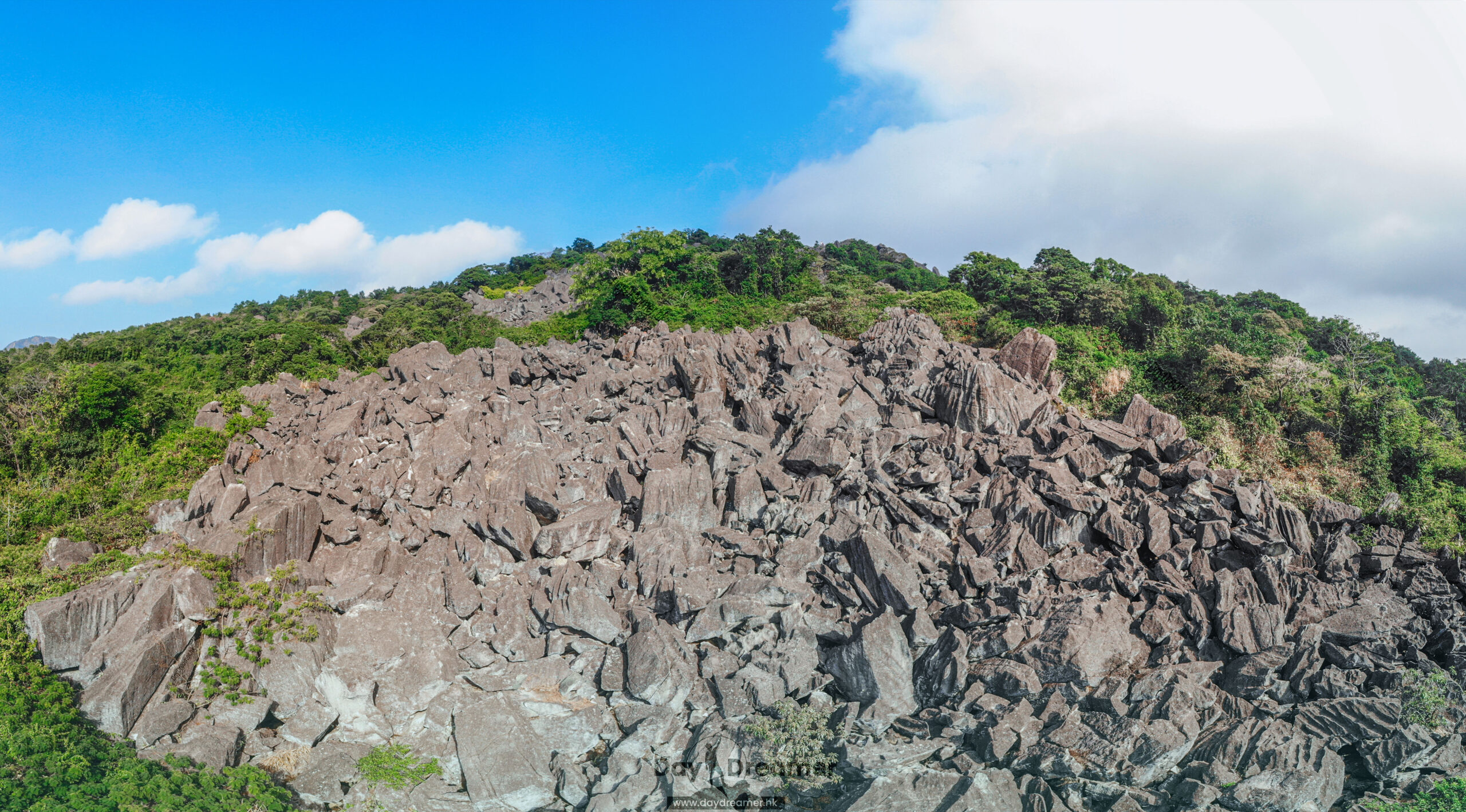
這張照片用作馬鞍山鹿巢山行山攻略的文章封面圖。畫面全面展現了香港馬鞍山郊野公園內著名的「鹿巢山石林」(Luk Chau Shan Rock Forest)全景,坡面上佈滿了因漫長地質風化而崩落的巨大火山岩(凝灰岩),與周圍的矮樹叢、遠處山丘及清澈天空中飄過的白雲互相襯托。這裡以「獨木舟石」、「試劍石」等奇岩怪石聞名,是香港著名的探險健行與戶外攝影路線。

Route Overview

Chevalier Garden → Mui Tsz Lam Road → Shek Lung Tsai Ancient Path → Luk Chau Rock Forest → Ma On Shan Village → Yiu On Bus Terminus


【Start】 Kick things off from and head along . This stretch is relatively flat—perfect for a “warm-up”—and lined with dense woods that offer plenty of fresh air. Once you reach the vicinity of Mui Tsz Lam Village, you’ll spot a water gate; turn left there to enter the Ancient Path. This historic trail is well-defined and heavily marked with ribbons to guide the way. It winds through the jungle and is generally in good condition for all types of hikers. You’ll encounter a few forks in the path; keep to the right to head toward the Luk Chau Rock Forest.


【Finish】 The Luk Chau Rock Forest is the largest of its kind in Hong Kong, covering an area of 0.07km2. The rocks here come in all sorts of bizarre shapes, making for a truly spectacular 『moonscape』. Before diving into the rocks, it’s highly recommended to wear gloves, as the surfaces are rough and can easily 『shred』 your skin. There isn’t a fixed path through the forest, so feel free to explore and enjoy the 『scrambling』 fun. After navigating the stones, follow the mountain trail downhill to Village, an old settlement that still preserves many traditional buildings and heritage sites. Continue down Road and you’ll soon reach the Yiu On Bus Terminus to wrap up your adventure.

Duration
6.9 hrs
Distance
11.1 km
Highest Point
444 m
Scenery
3 ⭐️
Difficulty
4 ⭐️
Exposure Index
4 ⭐️
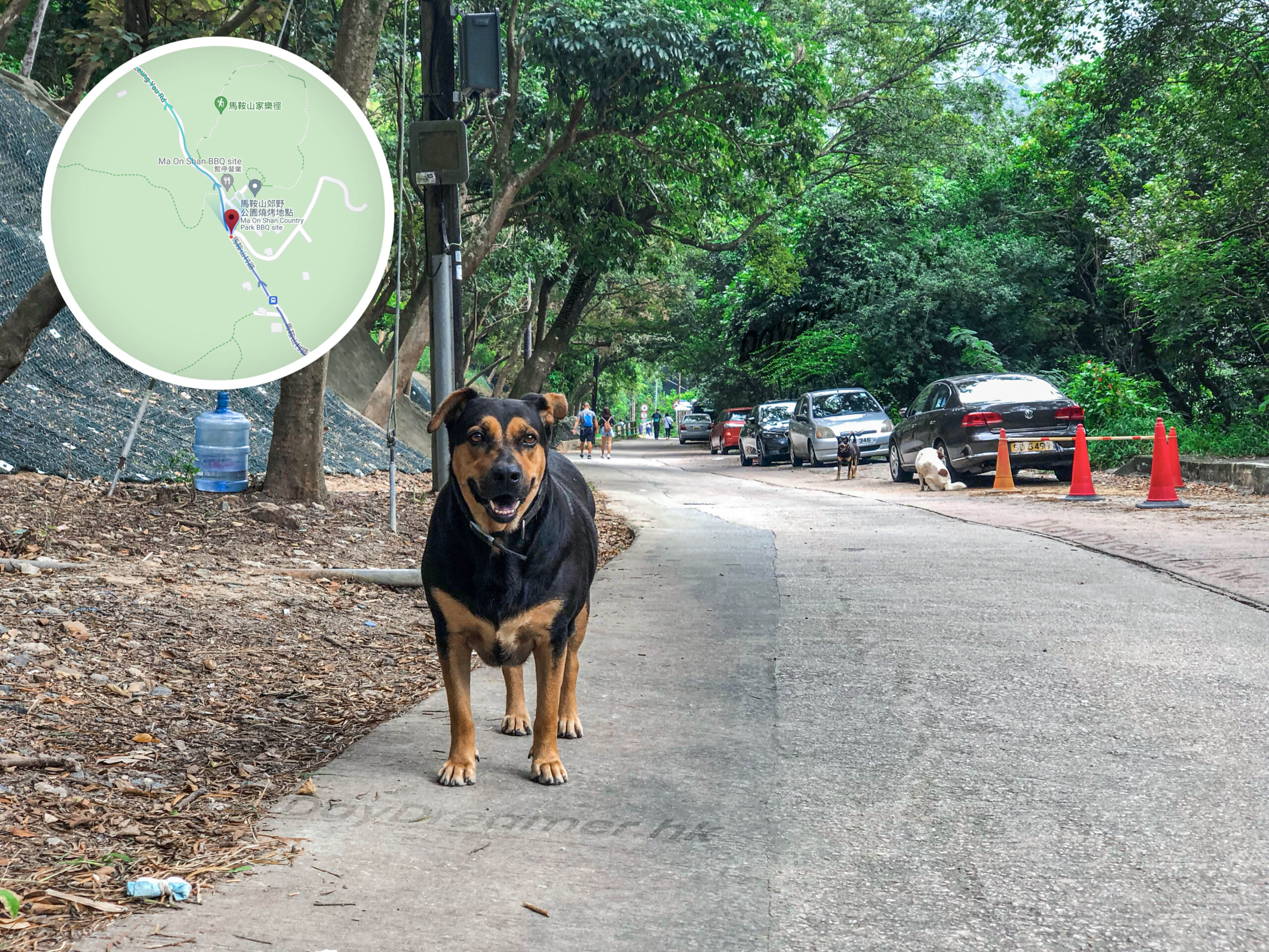
這張照片拍攝於香港馬鞍山郊野公園燒烤場旁的馬鞍山村路路段。畫面前方為一隻親人的黑褐色唐狗,後方則是綠蔭環繞的水泥道路,兩旁停放著零星車輛,並可見到遠處的健行遊客。此處是前往鹿巢山石林、昂坪高原或馬鞍山主峰的核心交通交匯點與行山起訖點(鄰近村巴 NR84 燒烤場站)。

Here are the reference statistics for this journey:

Total Ascent
567 m
Total Descent
572 m
Moving Speed
2.9 km/h
Average Speed
1.6 km/h
Moving Time
3.8 hrs
Total Journey Time
6.9 hrs

Related Videos

Transport Guide

START

🚩

Chevalier Garden

  1. Take the MTR to Station and walk to Chevalier Garden.
這張圖片是一幅精心標註的電子地圖截圖,用於說明香港馬鞍山一條遠足路線的詳細起點走法。地圖中央上方設有一個紅色定位大頭針,標示為「起點」,具體位置位於富安花園商場旁的OK便利店與巴士站附近。畫面上有一條帶有箭頭的粗藍色線條,指引遠足客從起點出發,向西穿過亞公角街花園與梅子林路交界,隨後沿著「梅子林路」向東南方向延伸前進。地圖上清晰可見周邊地標如馬鞍山崇真中學、富安花園各座樓宇、百佳超級市場及周邊食肆。
👉🏻

END

🏁

Yiu On Estate

  1. You can take various buses from here to other districts.
  2. Alternatively, walk to the nearby MTR Ma On Shan Station.
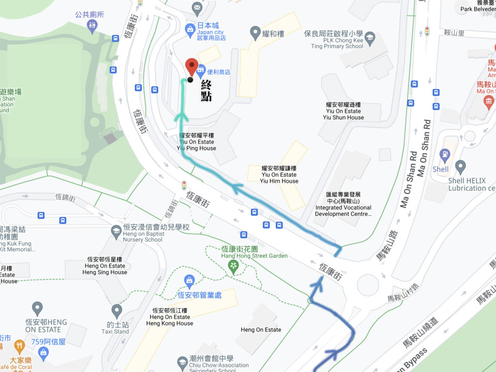
這張圖片為馬鞍山郊遊徑與鹿巢山石林行山路線的終點及交通撤退指南地圖。地圖詳細標示了行山人士自馬鞍山村路與馬鞍山繞道交界下山後,如何順著恆康街、經過恆康街花園,徒步引導至耀安邨耀平樓與耀禧樓旁的便利商店及日本城(即耀安商場附近)的「終點」標記位置。此處鄰近主要巴士站與的士站,方便健行客前往港鐵恆安站或轉乘其他交通工具。

Route Breakdown
🚶🏻‍➡️ Full Route 《Chevalier Garden → Luk Chau Rock Forest → Yiu On Bus Terminus》

1. 📍 Start: Chevalier Garden
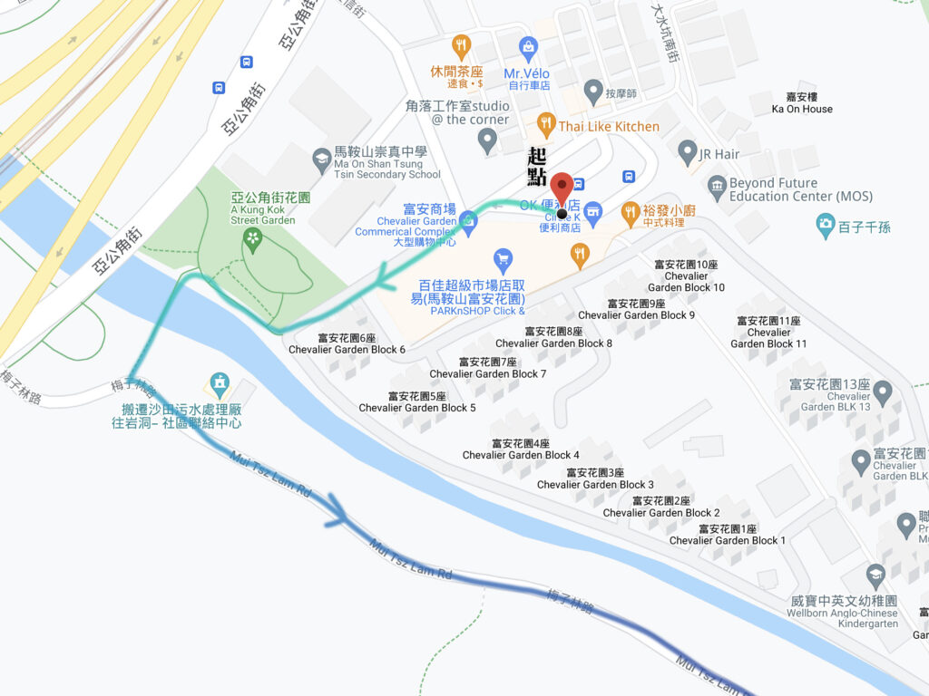
這張圖片是一幅精心標註的電子地圖截圖,用於說明香港馬鞍山一條遠足路線的詳細起點走法。地圖中央上方設有一個紅色定位大頭針,標示為「起點」,具體位置位於富安花園商場旁的OK便利店與巴士站附近。畫面上有一條帶有箭頭的粗藍色線條,指引遠足客從起點出發,向西穿過亞公角街花園與梅子林路交界,隨後沿著「梅子林路」向東南方向延伸前進。地圖上清晰可見周邊地標如馬鞍山崇真中學、富安花園各座樓宇、百佳超級市場及周邊食肆。

Chevalier Garden

Start: Set off from Chevalier Garden, pass through the Street Garden, and cross the small bridge over Luk Chau Hang. Turn left and head along Mui Tsz Lam Road.

2. 📍 Mui Tsz Lam Road

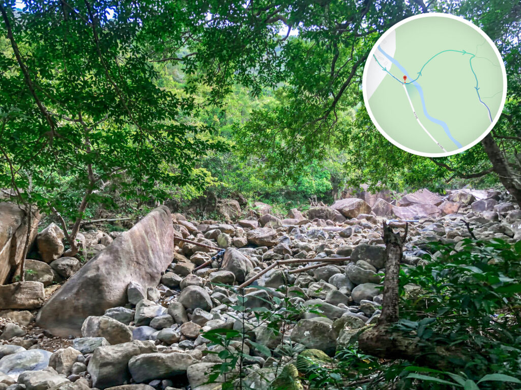
這張照片記錄了香港馬鞍山鹿巢山石林(或梅子林石澗段)原始叢林河床的壯麗地貌。畫面下方與中央長滿了密密麻麻、大小不一的灰色天然巨石與亂石,河床中間橫跨著幾條用於鄉郊引水的棕色與黑色鐵喉管。畫面上半部被極為茂密的翠綠樹冠與枝葉所遮蔽,陽光透過樹影灑在岩石表面,呈現出幽靜的野外秘境感。圖片右上角疊加了一個圓形綠色導航地圖,精準標示出目前位置正位於梅子林路末端、準備切入攀爬石林與石澗的溪谷起點位置。

Mui Tai Stream 《I》

Go straight along Mui Tsz Lam Road. Before reaching the rain shelter, turn left into the mountain trail and walk down toward Mui Tai Stream.
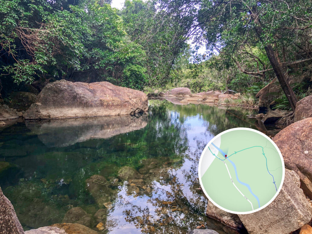
這張照片記錄了香港馬鞍山鹿巢山石林遠足路線(梅子林石澗段)的一處絕美水景。畫面中央為一個清澈透亮的天然深潭,水質在陽光折射下呈現迷人的翡翠綠與深藍漸層,透過水面可清晰看見潭底的砂石。水面平靜如鏡,完美倒映著上方的天空微光與兩旁茂密的叢林枝葉。左側矗立著一塊表面略帶青苔、線條方正的巨大深色岩石。圖片右下角疊加了一個圓形綠色導航地圖,精準標示出目前位置正位於梅子林溪谷的上游水潭分支點。

Mui Tai Stream 《II》

After crossing the stream, you’ll face an uphill climb toward the next stop: Luk Chau Au.
這張照片記錄了香港馬鞍山鹿巢山石林遠足路線中的鹿巢坳山徑。畫面中央是一條由碎石與裸露樹根構成的陡峭上行山路,展現出未經人工鋪設的天然鄉郊風貌。山徑兩側被茂密的翠綠樹木與灌木叢包圍,形成一條天然的綠色林蔭隧道。前方樹枝上掛有明顯的黃色與藍色行山絲帶,為行山人仕提供路線指引。圖片左上角疊加了一個圓形綠色導航地圖,標示出目前位置正由梅子林溪谷向上方山脊線與石林核心區域延伸。

Luk Chau Au

After a 90m vertical ascent, you’ll finally arrive at the mountain pass, Luk Chau Au.

3. 📍 Shek Lung Tsai Ancient Trail

這裡正是昔日石壟仔村(現已荒廢)居民進出馬鞍山與梅子林的歷史古道,沿途的梯田遺址與石牆與這片奇石林景觀交織。

Luk Chau Rock Forest, Hiking Entrance

Follow the stone path straight. When you see a stone bridge, turn left onto the slope to find the entrance to the Luk Chau Rock Forest. From here, proceed along the Shek Lung Tsai Ancient Trail.

4. 📍 Shek Lung Tsai Village, Ng Ancestral Hall

這張照片記錄了香港馬鞍山深山中「石壟仔村」客家遺址的歷史神秘氛圍。畫面中央與前景矗立著幾株生長極其茂盛、葉片巨大的翠綠大野芋(俗稱海芋或婆憂達),在陽光照射下脈絡清晰。植物後方被密密麻麻的荒山灌木、雜草與枯樹枝林所環繞,隱約可以看見昔日石壟仔村「吳氏家祠」與荒廢村屋的石牆結構,展現出廢墟與大自然融合的獨特景致。圖片右下角疊加了一個圓形綠色導航地圖,精準標示出目前位置正處於石壟仔石林下方、進入古村落核心遺址的轉折點。

Shek Lung Tsai Village, Ng Ancestral Hall

Continue along the ancient trail. Once you reach the Ng Ancestral Hall, turn left and walk for about 400m to reach the actual entrance for scrambling up the rock forest.

5. 📍 Luk Chau Rock Forest Entrance

這張照片記錄了香港馬鞍山「石壟仔主石林」的壯麗全景。採用由下而上的仰拍視角,畫面主體被滿山遍野、由數千塊巨大灰色火山礫岩天然堆疊而成的陡峭石坡所佔據。石群表面崎嶇嶙峋,展現出獨特的風化地貌,僅在岩石裂縫間長有稀疏的野草與小型植被。山脊上方點綴著翠綠的林木,遠處天空呈現多雲的藍天白雲景致。圖片左上角疊加了一個圓形綠色導航地圖,精準標示出目前位置正處於鹿巢山副石林前往主石林(試劍石)核心區的陡峭攀爬點。

Luk Chau Rock Forest Entrance

After a challenging trek, you’ve reached the entrance to the rock forest. The next section is a pure 『rock scrambling』 journey.

6. 📍 Luk Chau Rock Forest

這張照片展示了香港馬鞍山郊野公園內著名的「鹿巢山石林」(又稱鹿巢石林)。畫面中佈滿了因風化而形成的巨大灰色火山岩石群,周圍環繞著翠綠的植被與清澈的藍天白雲。

Luk Chau Stone Forest (鹿巢石林)

Seeing such a spectacular rock forest makes the grueling climb totally worth it! The views here are 『next level』.

7. 📍 Ma On Shan Mining Heritage Centre

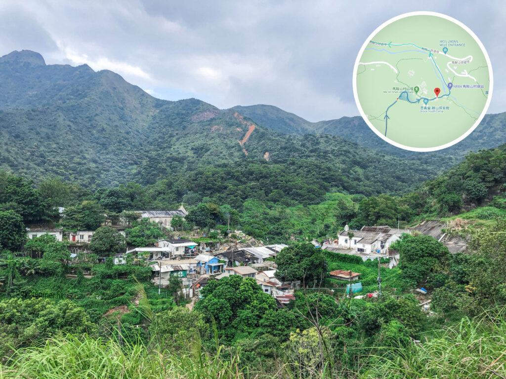
這張照片記錄了香港馬鞍山郊野公園內馬鞍山村的景觀。畫面中央為座落於山谷樹林間的「馬鞍山村」,背景則是氣勢雄偉的馬鞍山群峰(吊手岩一帶)。這條路線不僅能欣賞壯麗的自然山景,更能一窺昔日香港鐵礦業留下的礦村聚落風貌。

Ma On Shan Village

After scrambling through two sections of the rock forest, follow the mountain trail toward 
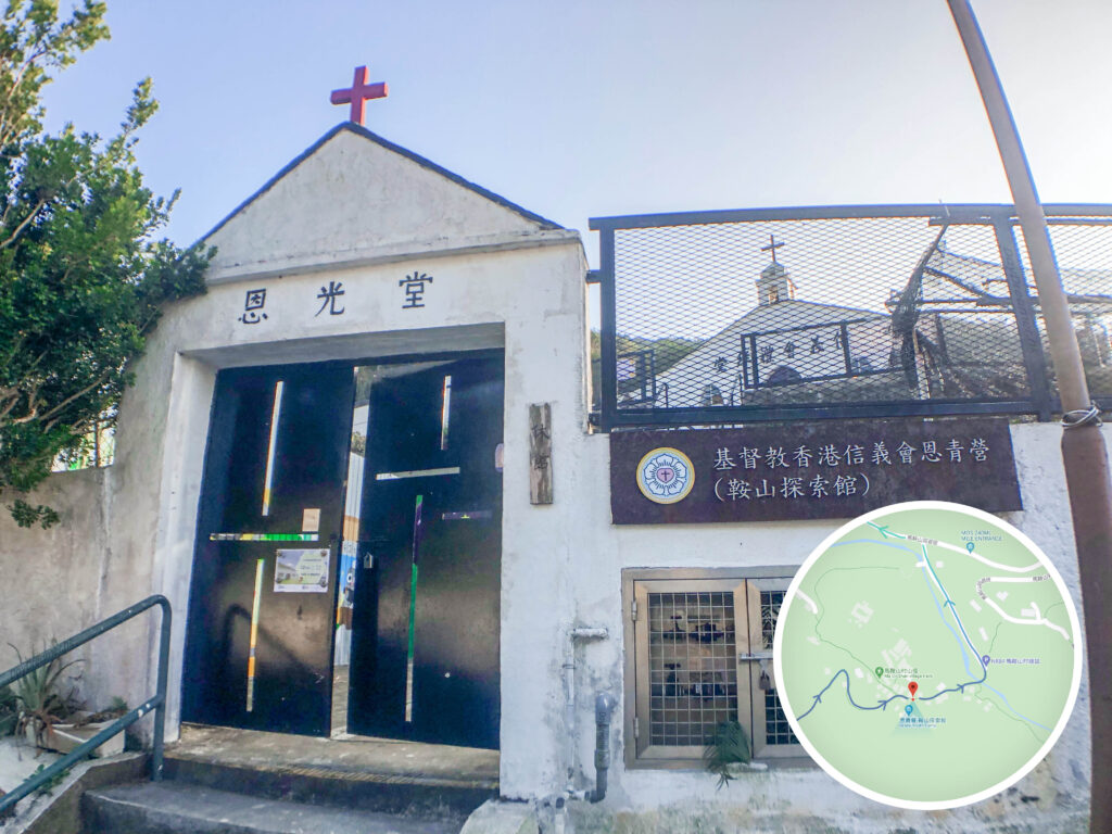
這張照片記錄了位於香港馬鞍山村的二級歷史建築——基督教香港信義會恩光堂(現為鞍山探索館/恩青營)的外觀入口。建築保留了昔日服務礦工群體的獨特白色尖頂與紅十字架設計。這裡不僅記錄了 1950-1960 年代馬鞍山鐵礦場全盛時期的村落發展與宗教救濟歷史,如今更成為著名的行山中途休息站與歷史保育基地。

Ma On Shan Mining Heritage Centre

At the foot of the mountain, you’ll enter the village and pass the (鞍山探索館). This unique building offers insights into Hong Kong’s old mining village culture and history — definitely worth a visit if you have time.

8. 📍 Ma On Shan Village

這張照片記錄了香港馬鞍山郊野公園內「馬鞍山村」的經典全景。畫面中可以清晰看見座落於茂密翠綠山谷間的村落平房,其中隱約可見左方山坡上的前馬鞍山信徒組成的天主堂(聖若瑟堂)以及右方的基督教信義會恩光堂。背景則是氣勢磅礡、山壁陡峭的馬鞍山群峰(包含吊手岩與牛押山一帶),展現出獨特的「山城」歷史感與自然景致。

Ma On Shan Village (馬鞍山村)

This was once a unique mining community, a rare piece of Hong Kong’s industrial heritage.

9. 📍 Ma On Shan Village Junction

這張照片拍攝於香港馬鞍山郊野公園的馬鞍山郊遊徑(鄰近馬鞍山村路交界)。畫面中央為漁農自然護理署設立的行山指示牌,清晰標示了往「恆安邨」(2.0公里,步行約1小時)及往「昂平」(1.1公里,步行約45分鐘)的路程與時間,是行山人士規劃行程、確認位置或選擇撤退路線時的重要參考依據。

Ma On Shan Village Junction

Leave the village and look for the signpost at the junction. Turn left and head toward Heng On Estate.

10. 📍 Ma On Shan BBQ Site

這張照片拍攝於香港馬鞍山郊野公園燒烤場旁的馬鞍山村路路段。畫面前方為一隻親人的黑褐色唐狗,後方則是綠蔭環繞的水泥道路,兩旁停放著零星車輛,並可見到遠處的健行遊客。此處是前往鹿巢山石林、昂坪高原或馬鞍山主峰的核心交通交匯點與行山起訖點(鄰近村巴 NR84 燒烤場站)。

Ma On Shan • BBQ Site

Continue along the paved road for about 1km to reach the Ma On Shan BBQ Site. There are restrooms and vending machines here. You might even run into some friendly local 『doggos』 (🐶 汪星人)!

11. 📍 Ma On Shan Village Road

這張照片記錄了香港馬鞍山村路(前往馬鞍山郊野公園、昂坪草原與鹿巢山石林的徒步路線)起段的經典街景。畫面中央為一座長形石屎護土牆,牆面上髹有醒目的紅色「南無阿彌陀佛」佛教佛號字樣,基座帶有防撞用的黃黑相間斜紋,周圍被茂密的山林綠意環繞。此地標位於從耀安或恆安邨後方切入馬鞍山村路的斜路段,是登山客徒步上山時必經的認路標誌。

Ma On Shan Village Road

Follow the road, pass the roundabout, and then turn left into a small mountain trail to begin the final descent.

12. 📍 Finish: Yiu On Estate, Bus Terminus

這張圖片為馬鞍山郊遊徑與鹿巢山石林行山路線的終點及交通撤退指南地圖。地圖詳細標示了行山人士自馬鞍山村路與馬鞍山繞道交界下山後,如何順著恆康街、經過恆康街花園,徒步引導至耀安邨耀平樓與耀禧樓旁的便利商店及日本城(即耀安商場附近)的「終點」標記位置。此處鄰近主要巴士站與的士站,方便健行客前往港鐵恆安站或轉乘其他交通工具。

Yiu On Estate, Bus Terminus

The trail leads you back to the urban area. Pass Heng On Estate (恆安邨) and walk a bit further to reach the finish line at  (耀安邨).