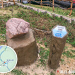
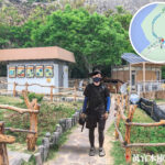
🛖 【High Island Reservoir East Dam Pavilion (東壩 涼亭)】 is a rest stop within the Hong Kong UNESCO Global Geopark that offers both practical utility and scenic value. It is located at the end of the main dam of the High Island Reservoir East Dam, directly facing the Po Pin Chau (破邊洲) sea stack and the vast South China Sea. Featuring a traditional Chinese design with red pillars and grey tiles, the pavilion stands out against the surrounding geological wonders. It serves as an ideal spot for visitors to take a break and enjoy the ocean view after exploring the hexagonal rock columns and the anchor-shaped dolosse breakwater. —
📌 Fast Facts
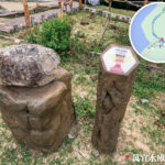
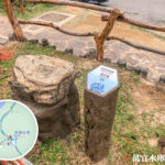
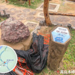
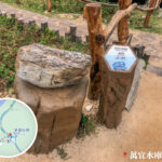
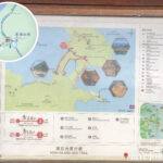
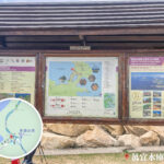
Item Details 🏕️ Pavilion Name High Island Reservoir East Dam《Pavilion》 (東壩 涼亭) 📍 Location Next to the High Island Reservoir East Dam, Sai Kung (西貢) East Country Park, Hong Kong 🌐 Geo-coordinates Approx. 22°21′50″N, 114°22′20″E 🧭 Nearby Trails & Spots MacLehose Trail Section 1 (麥理浩徑 第1段), High Island Geo Trail (萬宜地質步道), Biu Tsim Kok Viewing Point (標尖角 觀景台), Po Pin Chau (破邊洲) 🪨 Geological Wonders A cluster of hexagonal columns of rhyolitic volcanic rock formed by a volcanic eruption 140 million years ago, with diameters reaching up to 3 metres, covering an area of over 100 square kilometres. 🧱 Pavilion Facilities Pavilion, information boards, viewing platform, trails, seating area, display panels 🌊 Breakwater Features The subsidiary dam is made up of over 2,500 double-T-shaped concrete dolosse blocks to buffer the open sea waves. 🚌 Getting There 🚕 Direct by taxi (weekdays) | 🚌 On weekends/public holidays, take a KMB bus to Pak Tam Chung (北潭涌), then change to green minibus 9A to the East Dam terminus. 📷 Recommended Activities Hiking, photography, sightseeing geological wonders, catching the sunrise, eco-education, exploring sea caves and warped rock columns 🏞️ Scenic Highlights Stunning natural views including ocean panoramas, reservoir vistas, the rock column “sanctuary”, Long Ke Wan (浪茄灣), Tsang Pang Kok Tsui (罾棚角咀), Fan Tsang Chau (飯甑洲), and Po Pin Chau (破邊洲). 🧭 Suggested Hiking Route East Dam Pavilion → Biu Tsim Kok Viewing Point (標尖角 觀景台) → High Island Geo Trail (萬宜地質步道) → Kwun Mun Sea Cave (官門遺洞) → Sea Cave → Breakwater → Kai Pei Wan (雞脾灣) → Kim Chu Wan (撿豬灣) → Po Pin Chau (破邊洲) → Return to Pavilion. Total length approx. 12 km, takes about 5 hours. — To head to the pavilion, you can take green minibus 9A on weekends/holidays or grab a taxi to East Dam, followed by a quick 5-minute walk from the dam head. Heads up: there is zero shade around the pavilion and the sea breeze can get quite intense, so remember to pack a windbreaker and plenty of water. This pavilion isn’t just a breather for hikers; its unique location makes it a landmark that perfectly blends raw natural beauty with visitor amenities. —
🗺 Location & Transport
Item Details 📍 Location At the top of High Island Reservoir East Dam, within Sai Kung (西貢) East Country Park 🚗 Transport On weekends/holidays, hop on KMB routes 94 / 96R or green minibus 9A to East Dam Terminus; on weekdays, taking a taxi is your best bet. 🚶♂️ Starting Point for Walks You can set off from Pak Tam Chung (北潭涌) and hike along MacLehose Trail Section 1 (麥理浩徑 第1段) to Man Yee Au (萬宜坳), then head onto Man Yee Road (萬宜路) to reach East Dam Pavilion. — The pavilion is way more than just a lookout point—it’s a major transport and trail junction. It marks the finish line of MacLehose Trail Section 1 (麥理浩徑 第1段) and the starting point of MacLehose Trail Section 2, leading onwards to Long Ke Wan (浪茄灣) or back to the East Dam vehicle pickup point. Since it sits right across from Po Pin Chau (破邊洲) and High Island Enclosure (糧船灣海), it boasts wide-open, unobstructed views. It has become a massive hotspot for shutterbugs capturing sunrises, crashing waves, and geographical rock formations, while the geological signboards inside offer a great scientific intro to the local volcanic terrain. —
🛖 Pavilion Facilities & Architectural Features
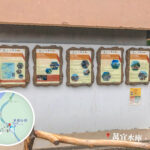
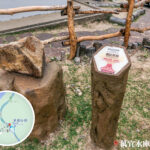
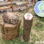
Item Description Architectural Style Chinese-style hexagonal pavilion with red pillars and grey tiles, blending nature with culture. Materials Used Reinforced concrete structure built to withstand strong winds and heavy rain, ideal for coastal conditions. Rest Function A perfect pit-stop mid-hike, and a meeting point for several trails. Space Planning Fits about 10–15 people, fitted with benches and shaded areas. Nearby Amenities Information boards, trail markers, geological exhibition wall, viewing platform. Geo-education Geological signboards are installed nearby to explain rock columns, sea caves, and coastal landforms. Design Concept Brings together a triple function of ‘sightseeing, education, and relaxation’ to coexist harmoniously with the landscape. —
🌄 Landscape & Views
The pavilion sits in a premium spot for taking in both High Island Reservoir and the South China Sea:
- Looking North: The glassy, mirror-like waters of High Island Reservoir, framed by rolling green ridges.
- Looking South: The sparkling South China Sea; on clear days, coastal features like Fan Tsang Chau (飯甑洲) and Tsang Pang Kok Tsui (罾棚角咀) are fully visible.
- Looking West: A bird’s-eye view of Biu Tsim Kok (標尖角) headland and the pristine sands of Long Ke Wan (浪茄灣).
- Looking East: Unmatched views of the rocky coast of Po Pin Chau (破邊洲) and its sea caves.
—
🔬 Geological Wonders Overview
🌋 Hexagonal Volcanic Columns (六角形 岩柱群)
- Formed around 140 million years ago following a massive super-volcano eruption, where cooling and contracting lava created hexagonal joints.
- The rock type is rhyolitic tuff (流紋質凝灰岩), completely different from your typical basalt.
- Columns reach up to 3 metres in diameter and span an area of over 100 square kilometres, outscaling the Giant’s Causeway in Northern Ireland.
🌀 S-shaped Warped Columns & Fault Breccia Belt
- The warped rock columns were bent by later tectonic movements into unique S-shapes, making them a true geological masterpiece.
- The fault breccia belt consists of fractured rock pieces, showing clear evidence of historical fault line activities.
🌊 Sea Caves & Sea Arches
- Volcanic rocks eroded by waves over time formed deep caves, which are now protected from further erosion by the breakwater.
- The sea caves create fascinating echo effects inside due to their wave-carved structures.
- The sea arch rises up to 30 metres and looks remarkably like a map of Taiwan—it is a famous landmark of Wang Chau (橫洲).
—
Wang Chau (橫洲) High Island Reservoir East Dam —
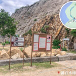
🥾 Recommended Hiking Route: High Island Geo Trail
Route Name High Island Geo Trail (萬宜地質步道) Starting Point East Dam Pavilion / Dolosse Monument Route Highlights East Dam Pavilion → Biu Tsim Kok Viewing Point (標尖角 觀景台) → Hexagonal Rock Columns → Warped Columns → Sea Cave → Breakwater → East Dam Pavilion Distance & Time Approx. 3.3 km, takes 2–3 hours (including rest and photo stops) Difficulty ⭐ (Beginner-friendly) Things to Note No tree shade along the way, so sun protection and hydration are key. Please do not climb on or damage any geological features. 🚶♂️ Suggested Itinerary
Time Activity Plan Morning Arrive at the pavilion by minibus, check out the geo-info signs and the massive rock columns. Noon Have a picnic at the pavilion or up at Biu Tsim Kok Viewing Point (標尖角 觀景台) while enjoying the coastal breeze. Afternoon Walk down the trail to the sea cave and Biu Tsim Kok (標尖角) to snap some Instagram-worthy shots. Evening Head back to the pavilion to catch a ride or hike back down to Pak Tam Chung (北潭涌). —
🧳 Pre-trip Checklist
- 🧴 Sun protection (hat, sunglasses, sunblock)
- 🥤 Plenty of drinking water and light snacks
- 📱 Make sure your phone is fully charged for photos and navigation
- 🗺 Consider swinging by the Volcano Discovery Centre in Sai Kung (西貢) first to grab maps and guide leaflets.
—
✅ Points to Note
- ☀️ There is zero shade along the trail, so come fully prepared for sun exposure and keep hydrating.
- 🗑️ Please “leave no trace”—don’t leave trash behind or scratch the rocks. Protect our geological heritage.
- 🐟 Do not mimic those who release goldfish into the lagoon, as it seriously messes up the local ecosystem.
- ❌ Absolutely no climbing on the rock columns, and please don’t feed the wild animals.
—
📸 Top Photo Spots
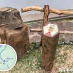
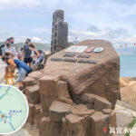
Spot Description Biu Tsim Kok Viewing Point (標尖角 觀景台) Serves up a stunning 270-degree panorama overlooking Long Ke Wan (浪茄灣), Po Pin Chau (破邊洲), Tsang Pang Kok Tsui (罾棚角咀), etc. Anchor Monument Built in memory of the workers who lost their lives constructing High Island Reservoir; it marks the official start of the geo trail. The Breakwater Constructed from over 7,000 dolosse blocks, looking like a massive, striking stack of giant concrete toys. Music Video Location ViuTV’s reality show “King Maker IV” filmed the music video for their theme song “Pre-round” (前傳) right here, turning it into a massive hit spot for Instagrammers. —
🧠 Trivia & Culture
- High Island Reservoir used to be a channel separating High Island (糧船灣洲) from the Sai Kung Peninsula, until the East Dam connected them into one landmass.
- The pavilion serves as a prime starting point for eco-education, letting locals learn science directly from nature.
- In 2022, the High Island hexagonal rock columns were selected as one of the First 100 IUGS Geological Heritage Sites, cementing their global scientific significance.
—
🧭 Extended Trail Options
- 🔹 Po Pin Chau (破邊洲): A sea stack blasted away from Fa Shan (花山) by coastal erosion, standing tall like giant organ pipes slicing into the sea.
- 🔹 Long Ke Wan (浪茄灣): A beach famous for its crystal-clear, Maldives-like turquoise water, making it a stellar summer hike destination.
- 🔹 Kim Chu Wan (撿豬灣) / Kai Pei Wan (雞脾灣): Accessible via coastal trails, featuring basic camping spots perfect for a day trip.
—
🔗 Further Reading
- Hong Kong Geopark Official Guide: High Island Reservoir East Dam
- DayDreamer Feature Article: East Dam Pavilion & Geo Trail
—