2022.04.10 SUN
【Hiking • 014】
Cheung Pai Tau – Sky Pool . Luk Keng. Kuk Po . Yung Shue Au
長排頭天池 . 鹿頸 . 谷埔 . 榕樹凹
This hiking route kicks off from Luk Keng, hitting Tiu Tang Lung Path, Fung Hang, Kuk Po, Yung Shue Au, Tai Sum Chung, Cheung Pai Tau, and the Sky Pool, before finally doubling back to Nam Chung. It’s a scenic trail packed with natural wonders, perfect for hikers who love a bit of exploration. The whole loop is about 18km and takes roughly 7 hours to complete, so it’s best suited for those with decent fitness. This route doesn’t just offer killer views of Hong Kong’s natural beauty — it also lets you experience diverse ecosystems and local history, making it a must-try for any serious hiker.
Luk Keng → Tiu Tang Lung Path → Fung Hang → Kuk Po → Yung Shue Au → Tai Sum Chung → Cheung Pai Tau – Sky Pool → Nam Chung
Route Overview
Luk Keng → Tiu Tang Lung Path → Fung Hang → Kuk Po → Yung Shue Au → Tai Sum Chung → Cheung Pai Tau – Sky Pool → Nam Chung
【Start】 Setting off from Luk Keng, you’ll first hit the Tiu Tang Lung Path. This coastal trail offers some seriously stunning views. Along the way, you can check out the mangroves and wetland ecosystems — these aren’t just for show; they act as a natural barrier against the waves. Keep an eye out while you’re trekking, as you’ll see heaps of little red crabs scurrying around the mangroves, which definitely adds a bit of fun to the hike.
【Mid-section】
Next, the trail leads you into Fung Hang. It’s a tiny village with a few local 『store-cafes』 where you can grab some supplies or a quick snack. After passing through, you’ll reach Kuk Po. This is an old-school Hakka village with deep history; the ancient buildings and ruins are well worth exploring. One highlight is the Kai Choi School, a Grade 3 historic building with nearly 80 years of history. Although it’s abandoned now, it still keeps its classic architectural charm.
Leaving the village, you’ll enter Yung Shue Au. This spot is a total “”eye candy”” location with a long embankment where you can soak in the coastal scenery. Continue pushing on to Tai Sum Chung, a natural water source with crystal-clear water—the perfect spot to take a breather.
【Finish】
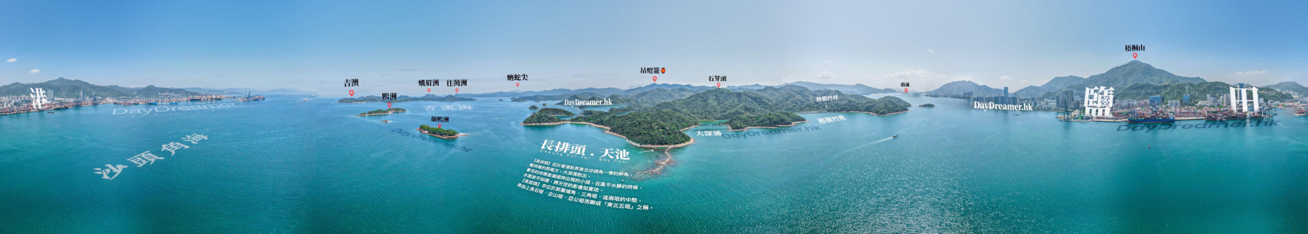
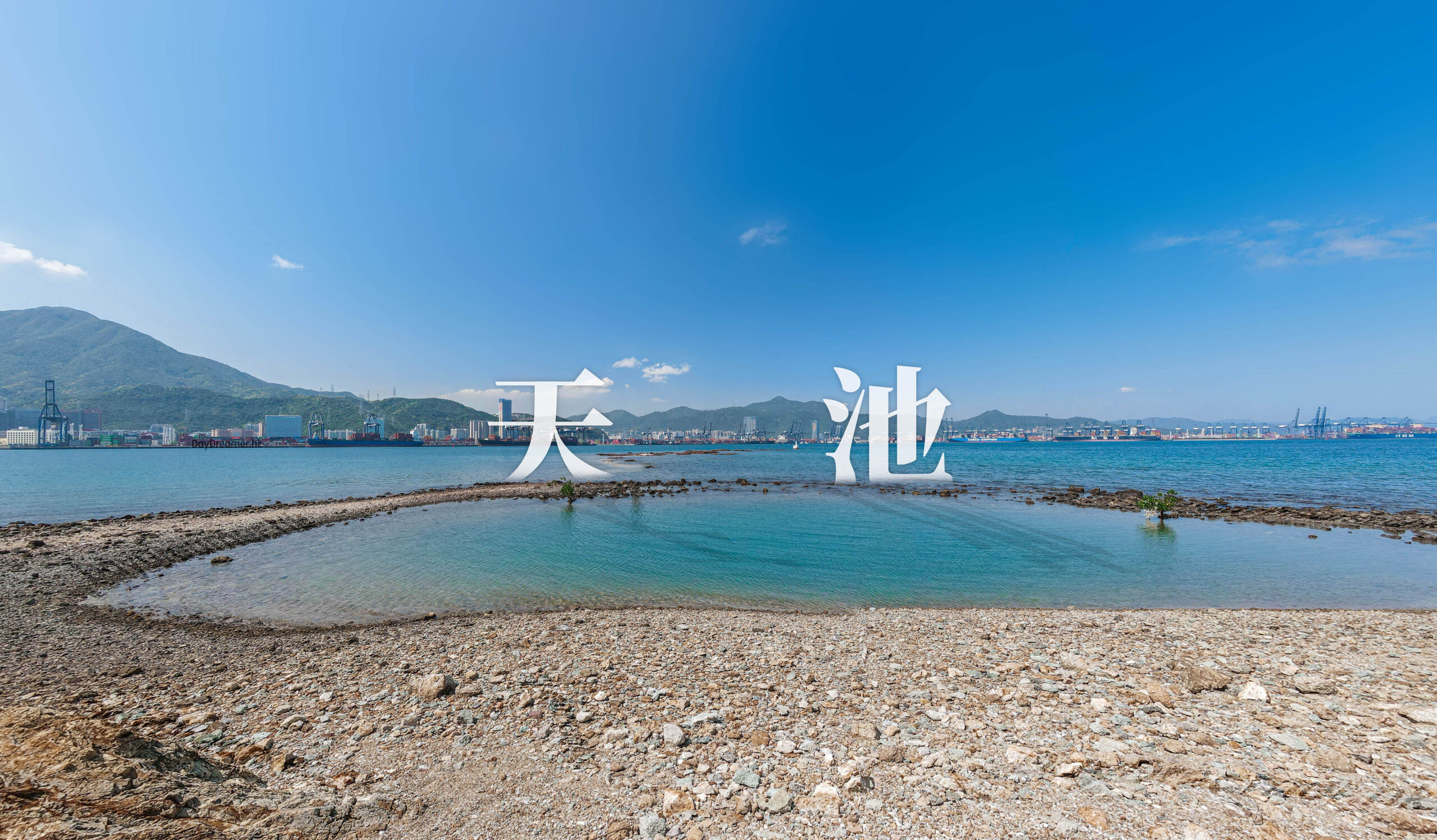
“From Tai Sum Chung, the route heads into Cheung Pai Tau and the Sky Pool. Cheung Pai Tau is a high point where you can overlook the entire area, while the Sky Pool is a natural pool with water so clear you can see the bottom. Surrounded by lush forest, it’s an incredibly chill and peaceful spot.
Finally, follow the same route back towards Luk Keng to finish up at Nam Chung. Nam Chung is a beautiful bay with fine sand and clear water, making it a solid end to the trip. The whole route is roughly 18km and takes about 7 hours, so it’s best for hikers with pretty good fitness.”
Here are the reference statistics for this journey:
Related Videos
Transport Guide
START
MTR Fanling Station, Exit C
- Take 《Green Minibus 56K》, get off at the Luk Keng terminus.
- Take a taxi, get off at Chan Fung Kee or BB Cafe in Luk Keng. The fare is roughly $120.

END
Nam Chung, Sha Tau Kok Road (Wo Hang Section
- Take 《Bus 78》 back to MTR Fanling Station.
- Take 《Bus 78K》 heading towards Sheung Shui, Tai Ping.

Route Breakdown
🚩
Outbound Route
《Luk Keng → Kuk Po → Cheung Pai Tau – Sky Pool》
1. 📍 Start: Luk Keng

Chan Fung Kee

BB Cafe
2. 📍 Bride’s Pool Road 《I》|Outbound

Bride’s Pool Road 《I》|Outbound
3. 📍 56K Minibus Terminus

56K Minibus Terminus

Sun Bok Pavilion
4. 📍 Kai Kuk Shue Ha

Kai Kuk Shue Ha
5. 📍 Fat Kee Store & Cafe

Fat Kee Store & Cafe
6. 📍 Tiu Tang Lung Path, Entrance

Tiu Tang Lung Path, Entrance

Plover Cove Country Park, Information Map 《I》
7. 📍 Tiu Tang Lung Path 《I》


Tiu Tang Lung Path 《I》
8. 📍 Tiu Tang Lung Path 《II》

Tiu Tang Lung Path 《II》
9. 📍 Tiu Tang Lung Path 《III》

Tiu Tang Lung Path 《III》
10. 📍 Tiu Tang Lung Path 《IV》

Plover Cove Country Park | Information Map 《II》
11. 📍 Tiu Tang Lung Path 《V》

Tiu Tang Lung Path 《V》
12. 📍 Tiu Tang Lung Path 《VI》

Tiu Tang Lung Path 《VI》
13. 📍 Tiu Tang Lung Path 《VII》

Kuk Po Seaside
14. 📍 Kuk Po


Kuk Po
15. 📍 Kuk Po, Chung Kee Store


Kuk Po, Chung Kee Store
📷 Tips:
- The village dog at Kuk Po might act like a 『waiter』 for Chung Kee Store. He’s very friendly to hikers passing by the junction. Because of his yellow fur, everyone calls him 『Ah Wong (阿黃)』.
16. 📍 Kuk Po Pier


Kuk Po Pier
17. 📍 Cheung Pai Tau Path, Entrance

Cheung Pai Tau Path, Entrance
18. 📍 Cheung Pai Tau Path 《I》


Cheung Pai Tau Path 《I》
19. 📍 Cheung Pai Tau Path 《II》


Cheung Pai Tau Path 《II》
This section is a lush, tree-lined mountain path. In addition to Cheung Pai Tau, this trail also connects to Lai Chi Wo.
20. 📍 Cheung Pai Tau Path 《III》

Cheung Pai Tau Path 《III》
21. 📍 Yung Shue Au Village, Entrance


Yung Shue Au Village, Entrance
After trekking about 3km from Kuk Po Pier, you’ll finally reach the next village, Yung Shue Au Village. At the village entrance, there is a signpost for Luk Keng, indicating that it’s a 4.8km walk back from this point.
22. 📍 Yung Shue Au Village 《I》


Yung Shue Au Village, Fuk On Kui
23. 📍 Yung Shue Au Village 《II》

Junction, Route Info Board
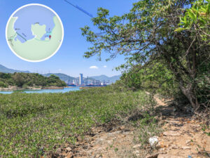
24. 📍 Yung Shue Au Wan

Yung Shue Au Wan
25. 📍 Cheung Pai Tau Path 《IV》

Cheung Pai Tau Path 《IV》
26. 📍 Tai Sham Chung Tuk 《I》


Tai Sham Chung Tuk 《I》
27. 📍 Tai Sham Chung Tuk 《II》

Tai Sham Chung Tuk 《II》
28. 📍 Tai Sham Chung 《I》

Tai Sham Chung 《I》
29. 📍 Tai Sham Chung 《II》

Tai Sham Chung 《II》
30. 📍 Tai Sham Chung 《III》

Tai Sham Chung 《III》
31. 📍 Tai Sham Chung 《IV》

Tai Sham Chung 《IV》
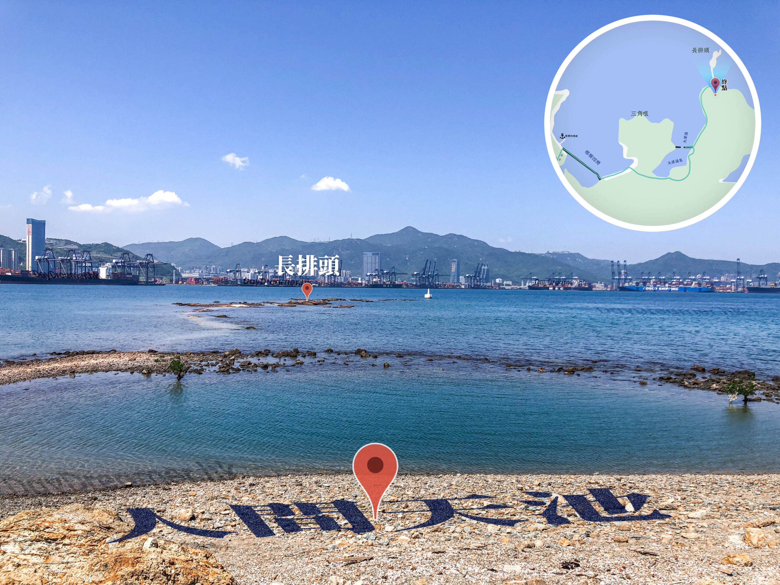
32. 📍 Cheung Pai Tau – Sky Pool

Cheung Pai Tau – Sky Pool

Cheung Pai Tau – Sky Pool 《180° View》
Route Breakdown
🏁
Return Route
《Cheung Pai Tau → Luk Keng → Nam Chung》
33. 📍 Tai Sum Chung, The Lone Tree

Tai Sum Chung, The Lone Tree 《II》
34. 📍 Tai Sum Chung Tuk, Bulldozer

Tai Sum Chung Tuk, Bulldozer
35. 📍 Yung Shue Au Village 《III》 |Return


Yung Shue Au Village, Tree House
36. 📍 Yung Shue Au Village 《IV》 |Return

Luk Keng / Lai Chi Wo – Signpost
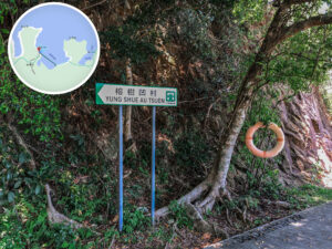
37. 📍 Yung Shue Au Village 《V》 |Return

Luk Keng / Lai Chi Wo / Wu Kau Tang – Signpost
38. 📍 Kuk Po, Chung Kee Store|Return

Kuk Po, Chung Kee Store
39. 📍 Uncle Sung’s Store

Uncle Sung’s Store
40. 📍 Tiu Tang Lung Path 《VIII》|Return

Lai Chi Wo / Fung Hang – Signpost
41. 📍 Fung Hang


Fung Hang
42. 📍 Tiu Tang Lung Path 《IX》|Return

Plover Cove Country Park|Info Map 《III》
43. 📍 Tiu Tang Lung Path 《X》|Return

Plover Cove Country Park|Info Map 《IV》
44. 📍 Bride’s Pool Road 《II》|Return

Bride’s Pool Road 《II》|Return
45. 📍 Nam Chung

Nam Chung
Walk along Bride’s Pool Road back to Luk Keng, then just keep following the road to reach Nam Chung.
46. 📍 Nam Chung, Tin Hau Temple


Nam Chung, Tin Hau Temple

Temple Notice Board
47. 📍 Luk Keng Road, Keung Kee Store

Luk Keng Road, Keung Kee Store
48. 📍 Luk Keng Road, Yeung Sum College

Luk Keng Road, Yeung Sum College
49. 📍 Pok Tau Ha

Shadow Warrior (影武者) 🥷

Pok Tau Ha
50. 📍 Yim Tso Ha Village

Yim Tso Ha Village
51. 📍 Luk Keng Road → Sha Tau Kok Road

Sha Tau Kok Road
52. 📍 Finish: Nam Chung, Bus Stop
Nam Chung, Bus Stop 《I》